You are here: Home > Network List > KZ - Kazakhstan Network Stations List
> Station TLG Talgar, Kazakstan > Earthquake Result Viewer
TLG Talgar, Kazakstan - Earthquake Result Viewer
| Earthquake location: |
Santa Cruz Islands |
| Earthquake latitude/longitude: |
-12.6/166.4 |
| Earthquake time(UTC): |
2002/06/17 (168) 21:26:22 GMT |
| Earthquake Depth: |
33 km |
| Earthquake Magnitude: |
6.0 MB, 6.7 MS, 6.7 MW, 6.6 MW |
| Earthquake Catalog/Contributor: |
WHDF/NEIC |
|
| Network: |
KZ Kazakhstan Network |
| Station: |
TLG Talgar, Kazakstan |
| Lat/Lon: |
43.23 N/77.22 E |
| Elevation: |
1120 m |
|
| Distance: |
97.9 deg |
| Az: |
312.457 deg |
| Baz: |
99.771 deg |
| Ray Param: |
0.040057108 |
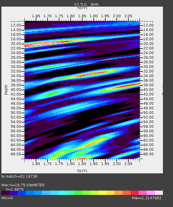
| Estimated Moho Depth: |
19.75 km |
| Estimated Crust Vp/Vs: |
1.69 |
| Assumed Crust Vp: |
6.306 km/s |
| Estimated Crust Vs: |
3.737 km/s |
| Estimated Crust Poisson's Ratio: |
0.23 |
|
| Radial Match: |
82.18739 % |
| Radial Bump: |
400 |
| Transverse Match: |
86.84321 % |
| Transverse Bump: |
400 |
| SOD ConfigId: |
20082 |
| Insert Time: |
2010-03-09 10:06:21.433 +0000 |
| GWidth: |
2.5 |
| Max Bumps: |
400 |
| Tol: |
0.001 |
|

Signal To Noise
| Channel | StoN | STA | LTA |
| KZ:TLG: :BHN:20020617T21:39:23.773027Z | 1.8307446 | 1.01995575E-7 | 5.5712615E-8 |
| KZ:TLG: :BHE:20020617T21:39:23.773027Z | 1.6596516 | 2.2954666E-7 | 1.3831014E-7 |
| KZ:TLG: :BHZ:20020617T21:39:23.773027Z | 3.0621493 | 2.2601431E-7 | 7.380905E-8 |
| Arrivals |
| Ps | 2.2 SECOND |
| PpPs | 8.3 SECOND |
| PsPs/PpSs | 10 SECOND |


