You are here: Home > Network List > KZ - Kazakhstan Network Stations List
> Station TLG Talgar, Kazakstan > Earthquake Result Viewer
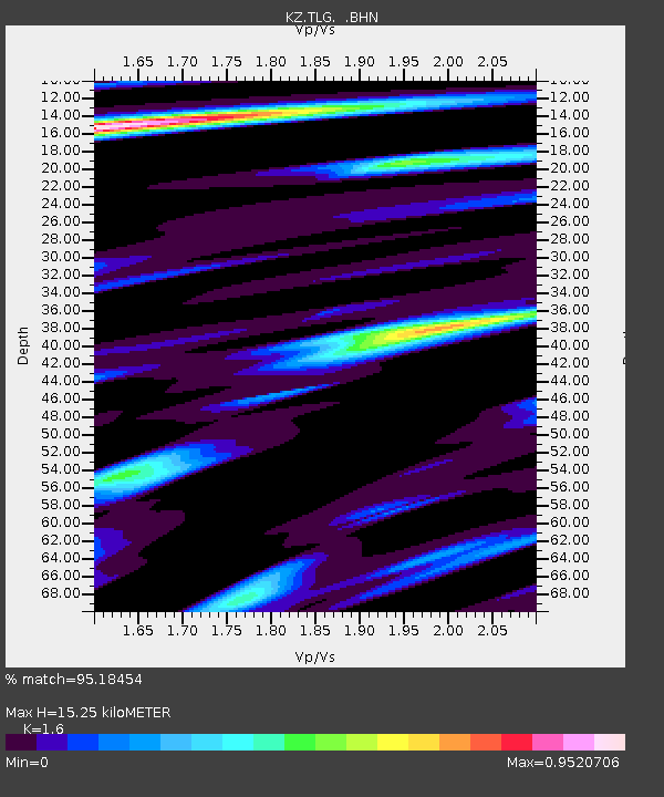
TLG Talgar, Kazakstan - Earthquake Result Viewer
| Earthquake location: |
South Of Alaska |
| Earthquake latitude/longitude: |
53.8/-161.1 |
| Earthquake time(UTC): |
2002/05/25 (145) 05:36:31 GMT |
| Earthquake Depth: |
33 km |
| Earthquake Magnitude: |
5.5 MB, 6.1 MS, 6.5 MW, 6.4 MW |
| Earthquake Catalog/Contributor: |
WHDF/NEIC |
|
| Network: |
KZ Kazakhstan Network |
| Station: |
TLG Talgar, Kazakstan |
| Lat/Lon: |
43.23 N/77.22 E |
| Elevation: |
1120 m |
|
| Distance: |
71.2 deg |
| Az: |
318.919 deg |
| Baz: |
32.219 deg |
| Ray Param: |
0.05443099 |
| Estimated Moho Depth: |
15.25 km |
| Estimated Crust Vp/Vs: |
1.60 |
| Assumed Crust Vp: |
6.306 km/s |
| Estimated Crust Vs: |
3.941 km/s |
| Estimated Crust Poisson's Ratio: |
0.18 |
|
| Radial Match: |
95.18454 % |
| Radial Bump: |
303 |
| Transverse Match: |
80.420235 % |
| Transverse Bump: |
400 |
| SOD ConfigId: |
20082 |
| Insert Time: |
2010-03-09 10:06:24.880 +0000 |
| GWidth: |
2.5 |
| Max Bumps: |
400 |
| Tol: |
0.001 |
|

Signal To Noise
| Channel | StoN | STA | LTA |
| KZ:TLG: :BHN:20020525T05:47:16.634001Z | 2.3850932 | 1.2295529E-7 | 5.155156E-8 |
| KZ:TLG: :BHE:20020525T05:47:16.634001Z | 0.92562646 | 2.0339468E-7 | 2.197373E-7 |
| KZ:TLG: :BHZ:20020525T05:47:16.634001Z | 6.983818 | 3.9198292E-7 | 5.612731E-8 |
| Arrivals |
| Ps | 1.5 SECOND |
| PpPs | 6.1 SECOND |
| PsPs/PpSs | 7.6 SECOND |


