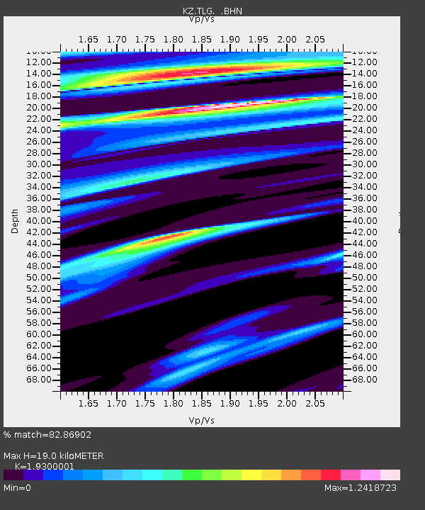
TLG Talgar, Kazakstan - Earthquake Result Viewer

Earthquake location: Southeast Of Honshu, Japan
Earthquake latitude/longitude: 33.5/138.1
Earthquake time(UTC): 1998/02/28 (059) 17:38:48 GMT
Earthquake Depth: 291 km
Earthquake Magnitude: 5.7 UNKNOWN, 5.3 MB, 5.7 MW
Earthquake Catalog/Contributor: WHDF/NEIC
Network: KZ Kazakhstan Network
Station: TLG Talgar, Kazakstan
Lat/Lon: 43.23 N/77.22 E
Elevation: 1120 m
Distance: 47.8 deg
Az: 300.457 deg
Baz: 80.399 deg
Ray Param: 0.0686038
Estimated Moho Depth: 19.0 km
Estimated Crust Vp/Vs: 1.93
Assumed Crust Vp: 6.306 km/s
Estimated Crust Vs: 3.267 km/s
Estimated Crust Poisson's Ratio: 0.32
Radial Match: 82.86902 %
Radial Bump: 384
Transverse Match: 86.2985 %
Transverse Bump: 400
SOD ConfigId: 4480
Insert Time: 2010-03-09 10:06:44.588 +0000
GWidth: 2.5
Max Bumps: 400
Tol: 0.001

Signal To Noise

ChannelStoNSTALTA
KZ:TLG: :BHN:19980228T17:46:26.64599Z2.10199261.3856381E-66.592022E-7
KZ:TLG: :BHE:19980228T17:46:26.64599Z0.77953285.737811E-77.3605776E-7
KZ:TLG: :BHZ:19980228T17:46:26.64599Z1.41685666.781151E-74.786053E-7
Arrivals
Ps3.0 SECOND
PpPs8.4 SECOND
PsPs/PpSs11 SECOND