You are here: Home > Network List > US - United States National Seismic Network Stations List
> Station CBKS Cedar Bluff, Kansas, USA > Earthquake Result Viewer
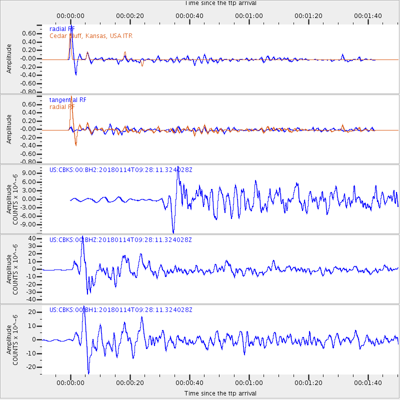
CBKS Cedar Bluff, Kansas, USA - Earthquake Result Viewer
| Earthquake location: |
Near Coast Of Peru |
| Earthquake latitude/longitude: |
-15.8/-74.7 |
| Earthquake time(UTC): |
2018/01/14 (014) 09:18:45 GMT |
| Earthquake Depth: |
36 km |
| Earthquake Magnitude: |
7.1 mww |
| Earthquake Catalog/Contributor: |
NEIC PDE/us |
|
| Network: |
US United States National Seismic Network |
| Station: |
CBKS Cedar Bluff, Kansas, USA |
| Lat/Lon: |
38.81 N/99.74 W |
| Elevation: |
677 m |
|
| Distance: |
59.1 deg |
| Az: |
337.384 deg |
| Baz: |
151.71 deg |
| Ray Param: |
0.062324356 |
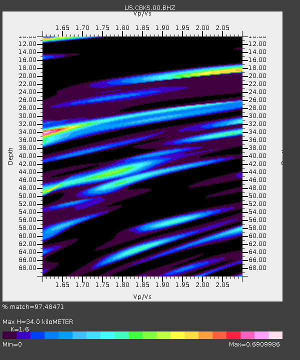
| Estimated Moho Depth: |
34.0 km |
| Estimated Crust Vp/Vs: |
1.60 |
| Assumed Crust Vp: |
6.483 km/s |
| Estimated Crust Vs: |
4.052 km/s |
| Estimated Crust Poisson's Ratio: |
0.18 |
|
| Radial Match: |
97.48471 % |
| Radial Bump: |
348 |
| Transverse Match: |
88.33912 % |
| Transverse Bump: |
400 |
| SOD ConfigId: |
2537391 |
| Insert Time: |
2018-01-28 09:24:46.697 +0000 |
| GWidth: |
2.5 |
| Max Bumps: |
400 |
| Tol: |
0.001 |
|
Signal To Noise
| Channel | StoN | STA | LTA |
| US:CBKS:00:BHZ:20180114T09:28:11.324028Z | 43.234848 | 1.5450314E-5 | 3.573579E-7 |
| US:CBKS:00:BH1:20180114T09:28:11.324028Z | 20.026814 | 9.064395E-6 | 4.5261294E-7 |
| US:CBKS:00:BH2:20180114T09:28:11.324028Z | 8.412142 | 4.1199482E-6 | 4.897621E-7 |
| Arrivals |
| Ps | 3.3 SECOND |
| PpPs | 13 SECOND |
| PsPs/PpSs | 16 SECOND |


