You are here: Home > Network List > CN - Canadian National Seismograph Network Stations List
> Station INK INUVIK, NT > Earthquake Result Viewer
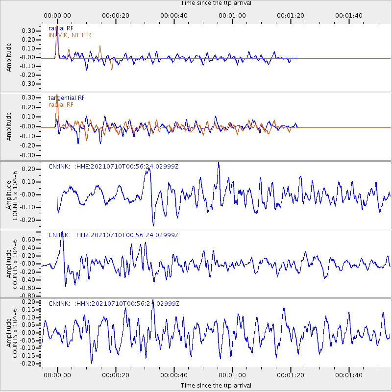
INK INUVIK, NT - Earthquake Result Viewer
*The percent match for this event was below the threshold and hence no stack was calculated.
| Earthquake location: |
Northern Molucca Sea |
| Earthquake latitude/longitude: |
2.9/126.5 |
| Earthquake time(UTC): |
2021/07/10 (191) 00:43:56 GMT |
| Earthquake Depth: |
45 km |
| Earthquake Magnitude: |
6.1 Mww |
| Earthquake Catalog/Contributor: |
NEIC PDE/us |
|
| Network: |
CN Canadian National Seismograph Network |
| Station: |
INK INUVIK, NT |
| Lat/Lon: |
68.31 N/133.53 W |
| Elevation: |
44 m |
|
| Distance: |
91.0 deg |
| Az: |
21.483 deg |
| Baz: |
280.348 deg |
| Ray Param: |
$rayparam |
*The percent match for this event was below the threshold and hence was not used in the summary stack. |
|
| Radial Match: |
66.0626 % |
| Radial Bump: |
309 |
| Transverse Match: |
64.17927 % |
| Transverse Bump: |
315 |
| SOD ConfigId: |
25131211 |
| Insert Time: |
2021-07-24 00:50:35.529 +0000 |
| GWidth: |
2.5 |
| Max Bumps: |
400 |
| Tol: |
0.001 |
|
Signal To Noise
| Channel | StoN | STA | LTA |
| CN:INK: :HHZ:20210710T00:56:24.02999Z | 5.7339034 | 3.7531115E-7 | 6.545474E-8 |
| CN:INK: :HHN:20210710T00:56:24.02999Z | 0.7888884 | 3.9763933E-8 | 5.0405013E-8 |
| CN:INK: :HHE:20210710T00:56:24.02999Z | 2.9357994 | 1.4370488E-7 | 4.8949147E-8 |
| Arrivals |
| Ps | |
| PpPs | |
| PsPs/PpSs | |


