You are here: Home > Network List > GO - National Seismic Network of Georgia Stations List
> Station TBLG Delisi, Georgia > Earthquake Result Viewer
TBLG Delisi, Georgia - Earthquake Result Viewer
| Earthquake location: |
Northern Molucca Sea |
| Earthquake latitude/longitude: |
2.9/126.5 |
| Earthquake time(UTC): |
2021/07/10 (191) 00:43:56 GMT |
| Earthquake Depth: |
45 km |
| Earthquake Magnitude: |
6.1 Mww |
| Earthquake Catalog/Contributor: |
NEIC PDE/us |
|
| Network: |
GO National Seismic Network of Georgia |
| Station: |
TBLG Delisi, Georgia |
| Lat/Lon: |
41.73 N/44.74 E |
| Elevation: |
510 m |
|
| Distance: |
81.9 deg |
| Az: |
311.562 deg |
| Baz: |
93.29 deg |
| Ray Param: |
0.047190353 |
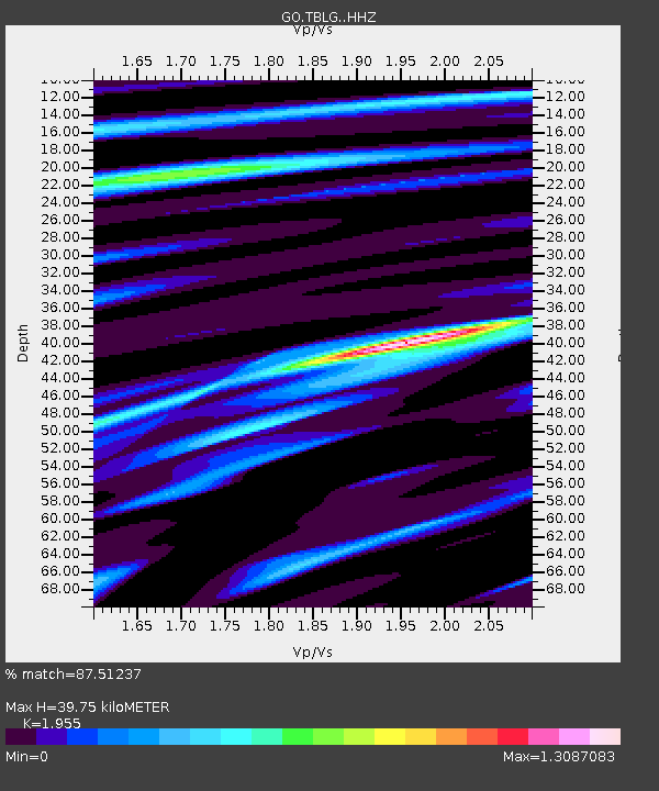
| Estimated Moho Depth: |
39.75 km |
| Estimated Crust Vp/Vs: |
1.96 |
| Assumed Crust Vp: |
6.291 km/s |
| Estimated Crust Vs: |
3.218 km/s |
| Estimated Crust Poisson's Ratio: |
0.32 |
|
| Radial Match: |
87.51237 % |
| Radial Bump: |
400 |
| Transverse Match: |
72.0403 % |
| Transverse Bump: |
350 |
| SOD ConfigId: |
25131211 |
| Insert Time: |
2021-07-24 00:51:19.968 +0000 |
| GWidth: |
2.5 |
| Max Bumps: |
400 |
| Tol: |
0.001 |
|

Signal To Noise
| Channel | StoN | STA | LTA |
| GO:TBLG: :HHZ:20210710T00:55:39.659995Z | 27.82438 | 2.0290406E-6 | 7.2923115E-8 |
| GO:TBLG: :HHN:20210710T00:55:39.659995Z | 2.5389488 | 2.2939298E-7 | 9.034959E-8 |
| GO:TBLG: :HHE:20210710T00:55:39.659995Z | 11.959553 | 6.81139E-7 | 5.695355E-8 |
| Arrivals |
| Ps | 6.2 SECOND |
| PpPs | 18 SECOND |
| PsPs/PpSs | 24 SECOND |


