You are here: Home > Network List > US - United States National Seismic Network Stations List
> Station VBMS Vicksburg, Mississippi > Earthquake Result Viewer
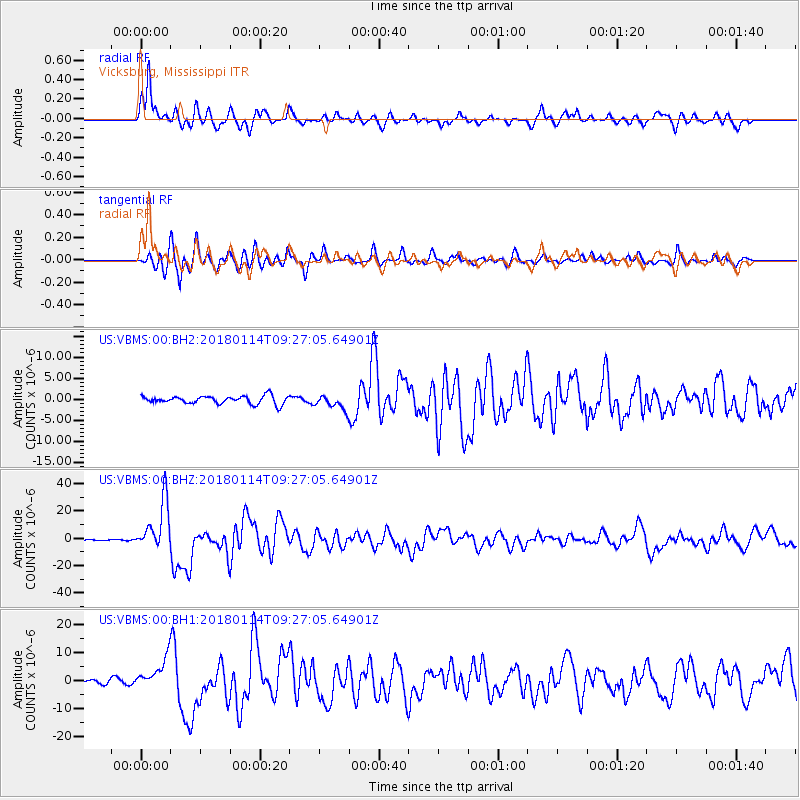
VBMS Vicksburg, Mississippi - Earthquake Result Viewer
*The percent match for this event was below the threshold and hence no stack was calculated.
| Earthquake location: |
Near Coast Of Peru |
| Earthquake latitude/longitude: |
-15.8/-74.7 |
| Earthquake time(UTC): |
2018/01/14 (014) 09:18:45 GMT |
| Earthquake Depth: |
36 km |
| Earthquake Magnitude: |
7.1 mww |
| Earthquake Catalog/Contributor: |
NEIC PDE/us |
|
| Network: |
US United States National Seismic Network |
| Station: |
VBMS Vicksburg, Mississippi |
| Lat/Lon: |
32.22 N/90.52 W |
| Elevation: |
16 m |
|
| Distance: |
50.1 deg |
| Az: |
342.51 deg |
| Baz: |
160.04 deg |
| Ray Param: |
$rayparam |
*The percent match for this event was below the threshold and hence was not used in the summary stack. |
|
| Radial Match: |
87.882576 % |
| Radial Bump: |
392 |
| Transverse Match: |
79.828674 % |
| Transverse Bump: |
400 |
| SOD ConfigId: |
2537391 |
| Insert Time: |
2018-01-28 09:25:50.921 +0000 |
| GWidth: |
2.5 |
| Max Bumps: |
400 |
| Tol: |
0.001 |
|
Signal To Noise
| Channel | StoN | STA | LTA |
| US:VBMS:00:BHZ:20180114T09:27:05.64901Z | 34.44699 | 1.8026865E-5 | 5.2332194E-7 |
| US:VBMS:00:BH1:20180114T09:27:05.64901Z | 4.4584126 | 5.481069E-6 | 1.2293767E-6 |
| US:VBMS:00:BH2:20180114T09:27:05.64901Z | 1.7635632 | 1.6581008E-6 | 9.401993E-7 |
| Arrivals |
| Ps | |
| PpPs | |
| PsPs/PpSs | |


