You are here: Home > Network List > AV - Alaska Volcano Observatory Stations List
> Station KAVE Katnai Ventifact, Alaska > Earthquake Result Viewer
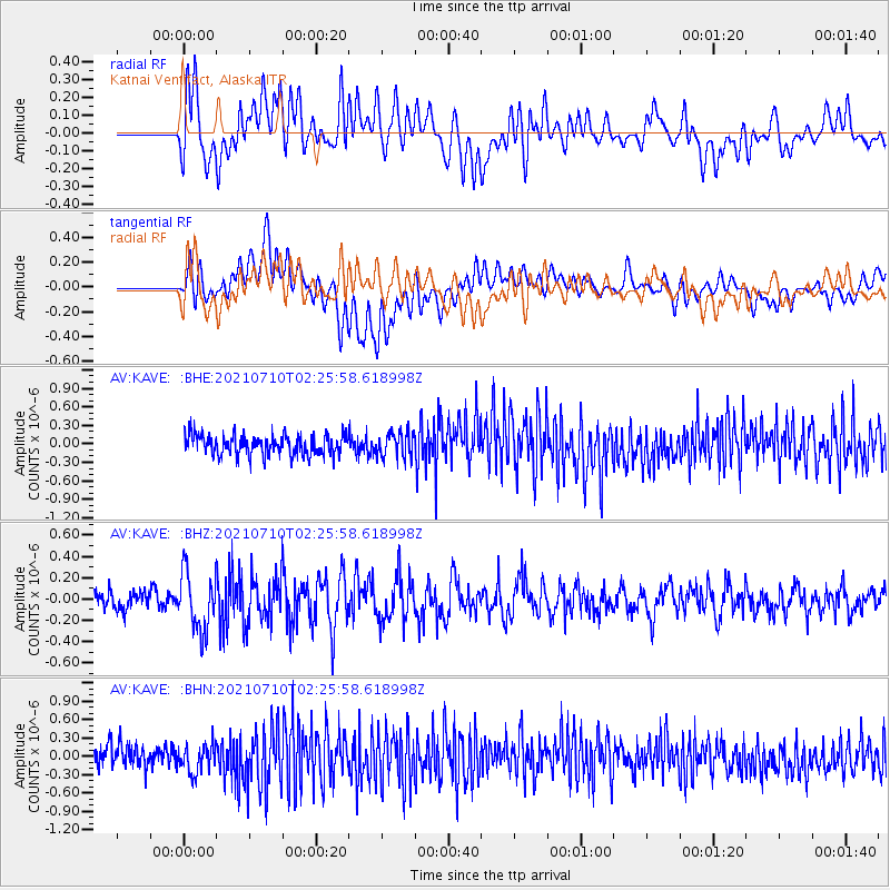
KAVE Katnai Ventifact, Alaska - Earthquake Result Viewer
*The percent match for this event was below the threshold and hence no stack was calculated.
| Earthquake location: |
Afghanistan-Tajikistan Bord Reg. |
| Earthquake latitude/longitude: |
39.0/70.6 |
| Earthquake time(UTC): |
2021/07/10 (191) 02:14:43 GMT |
| Earthquake Depth: |
17 km |
| Earthquake Magnitude: |
5.8 Mww |
| Earthquake Catalog/Contributor: |
NEIC PDE/us |
|
| Network: |
AV Alaska Volcano Observatory |
| Station: |
KAVE Katnai Ventifact, Alaska |
| Lat/Lon: |
58.20 N/155.02 W |
| Elevation: |
702 m |
|
| Distance: |
76.0 deg |
| Az: |
22.951 deg |
| Baz: |
324.963 deg |
| Ray Param: |
$rayparam |
*The percent match for this event was below the threshold and hence was not used in the summary stack. |
|
| Radial Match: |
50.80699 % |
| Radial Bump: |
400 |
| Transverse Match: |
60.0636 % |
| Transverse Bump: |
400 |
| SOD ConfigId: |
25131211 |
| Insert Time: |
2021-07-24 02:20:48.651 +0000 |
| GWidth: |
2.5 |
| Max Bumps: |
400 |
| Tol: |
0.001 |
|
Signal To Noise
| Channel | StoN | STA | LTA |
| AV:KAVE: :BHZ:20210710T02:25:58.618998Z | 3.3087428 | 2.7673707E-7 | 8.3638135E-8 |
| AV:KAVE: :BHN:20210710T02:25:58.618998Z | 1.2589989 | 2.3230724E-7 | 1.8451743E-7 |
| AV:KAVE: :BHE:20210710T02:25:58.618998Z | 1.225359 | 2.0504295E-7 | 1.6733297E-7 |
| Arrivals |
| Ps | |
| PpPs | |
| PsPs/PpSs | |


