You are here: Home > Network List > UU - University of Utah Regional Network Stations List
> Station BRPU Butcher Ranch, Price, UT, USA old TA-P17A > Earthquake Result Viewer
BRPU Butcher Ranch, Price, UT, USA old TA-P17A - Earthquake Result Viewer
| Earthquake location: |
Near Coast Of Peru |
| Earthquake latitude/longitude: |
-15.8/-74.7 |
| Earthquake time(UTC): |
2018/01/14 (014) 09:18:45 GMT |
| Earthquake Depth: |
36 km |
| Earthquake Magnitude: |
7.1 mww |
| Earthquake Catalog/Contributor: |
NEIC PDE/us |
|
| Network: |
UU University of Utah Regional Network |
| Station: |
BRPU Butcher Ranch, Price, UT, USA old TA-P17A |
| Lat/Lon: |
39.47 N/110.74 W |
| Elevation: |
1687 m |
|
| Distance: |
64.4 deg |
| Az: |
329.711 deg |
| Baz: |
141.142 deg |
| Ray Param: |
0.058875978 |
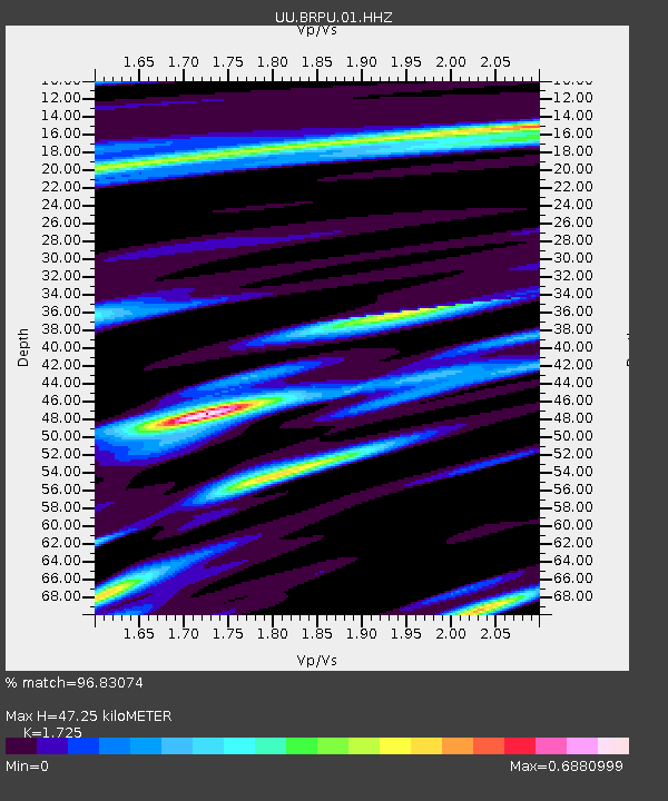
| Estimated Moho Depth: |
47.25 km |
| Estimated Crust Vp/Vs: |
1.73 |
| Assumed Crust Vp: |
6.207 km/s |
| Estimated Crust Vs: |
3.598 km/s |
| Estimated Crust Poisson's Ratio: |
0.25 |
|
| Radial Match: |
96.83074 % |
| Radial Bump: |
398 |
| Transverse Match: |
89.66064 % |
| Transverse Bump: |
400 |
| SOD ConfigId: |
2537391 |
| Insert Time: |
2018-01-28 09:26:00.503 +0000 |
| GWidth: |
2.5 |
| Max Bumps: |
400 |
| Tol: |
0.001 |
|

Signal To Noise
| Channel | StoN | STA | LTA |
| UU:BRPU:01:HHZ:20180114T09:28:46.788018Z | 42.383606 | 2.0145964E-7 | 4.753245E-9 |
| UU:BRPU:01:HHN:20180114T09:28:46.788018Z | 10.336319 | 5.358098E-8 | 5.183758E-9 |
| UU:BRPU:01:HHE:20180114T09:28:46.788018Z | 8.999848 | 4.0278337E-8 | 4.4754462E-9 |
| Arrivals |
| Ps | 5.7 SECOND |
| PpPs | 20 SECOND |
| PsPs/PpSs | 26 SECOND |


