You are here: Home > Network List > UU - University of Utah Regional Network Stations List
> Station FOR3 Blundell North, UT, USA > Earthquake Result Viewer
FOR3 Blundell North, UT, USA - Earthquake Result Viewer
| Earthquake location: |
Near Coast Of Peru |
| Earthquake latitude/longitude: |
-15.8/-74.7 |
| Earthquake time(UTC): |
2018/01/14 (014) 09:18:45 GMT |
| Earthquake Depth: |
36 km |
| Earthquake Magnitude: |
7.1 mww |
| Earthquake Catalog/Contributor: |
NEIC PDE/us |
|
| Network: |
UU University of Utah Regional Network |
| Station: |
FOR3 Blundell North, UT, USA |
| Lat/Lon: |
38.51 N/112.88 W |
| Elevation: |
1699 m |
|
| Distance: |
64.8 deg |
| Az: |
327.614 deg |
| Baz: |
138.9 deg |
| Ray Param: |
0.058659963 |
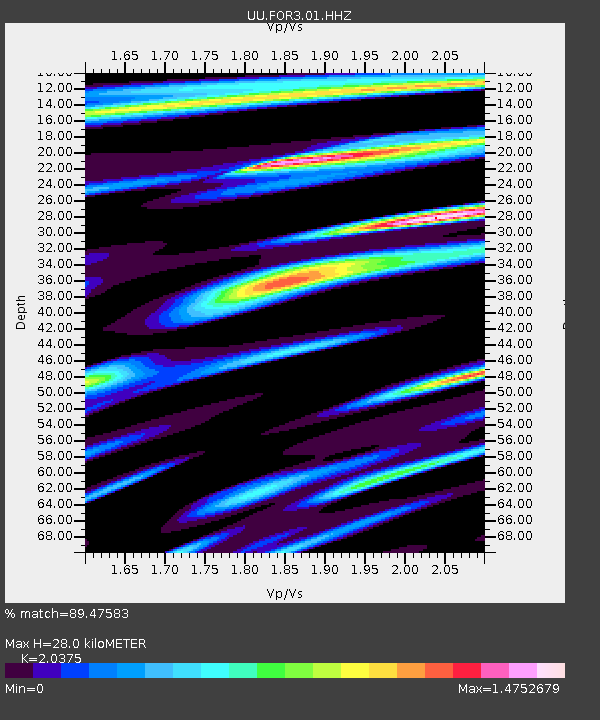
| Estimated Moho Depth: |
28.0 km |
| Estimated Crust Vp/Vs: |
2.04 |
| Assumed Crust Vp: |
6.276 km/s |
| Estimated Crust Vs: |
3.08 km/s |
| Estimated Crust Poisson's Ratio: |
0.34 |
|
| Radial Match: |
89.47583 % |
| Radial Bump: |
400 |
| Transverse Match: |
83.388016 % |
| Transverse Bump: |
400 |
| SOD ConfigId: |
2537391 |
| Insert Time: |
2018-01-28 09:26:11.288 +0000 |
| GWidth: |
2.5 |
| Max Bumps: |
400 |
| Tol: |
0.001 |
|

Signal To Noise
| Channel | StoN | STA | LTA |
| UU:FOR3:01:HHZ:20180114T09:28:48.989983Z | 10.093847 | 1.1079524E-7 | 1.0976512E-8 |
| UU:FOR3:01:HHN:20180114T09:28:48.989983Z | 3.4020448 | 4.354753E-8 | 1.2800399E-8 |
| UU:FOR3:01:HHE:20180114T09:28:48.989983Z | 2.92412 | 3.2367982E-8 | 1.1069308E-8 |
| Arrivals |
| Ps | 4.8 SECOND |
| PpPs | 13 SECOND |
| PsPs/PpSs | 18 SECOND |


