You are here: Home > Network List > UU - University of Utah Regional Network Stations List
> Station MTPU Mt. Pierson, UT, USA > Earthquake Result Viewer
MTPU Mt. Pierson, UT, USA - Earthquake Result Viewer
| Earthquake location: |
Near Coast Of Peru |
| Earthquake latitude/longitude: |
-15.8/-74.7 |
| Earthquake time(UTC): |
2018/01/14 (014) 09:18:45 GMT |
| Earthquake Depth: |
36 km |
| Earthquake Magnitude: |
7.1 mww |
| Earthquake Catalog/Contributor: |
NEIC PDE/us |
|
| Network: |
UU University of Utah Regional Network |
| Station: |
MTPU Mt. Pierson, UT, USA |
| Lat/Lon: |
38.04 N/112.18 W |
| Elevation: |
3112 m |
|
| Distance: |
64.0 deg |
| Az: |
327.732 deg |
| Baz: |
139.381 deg |
| Ray Param: |
0.05912006 |
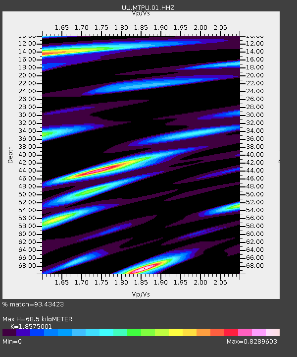
| Estimated Moho Depth: |
68.5 km |
| Estimated Crust Vp/Vs: |
1.86 |
| Assumed Crust Vp: |
6.276 km/s |
| Estimated Crust Vs: |
3.379 km/s |
| Estimated Crust Poisson's Ratio: |
0.30 |
|
| Radial Match: |
93.43423 % |
| Radial Bump: |
400 |
| Transverse Match: |
92.017624 % |
| Transverse Bump: |
400 |
| SOD ConfigId: |
2537391 |
| Insert Time: |
2018-01-28 09:26:25.276 +0000 |
| GWidth: |
2.5 |
| Max Bumps: |
400 |
| Tol: |
0.001 |
|

Signal To Noise
| Channel | StoN | STA | LTA |
| UU:MTPU:01:HHZ:20180114T09:28:44.327996Z | 13.717124 | 1.0832572E-7 | 7.897116E-9 |
| UU:MTPU:01:HHN:20180114T09:28:44.327996Z | 3.8013704 | 4.396728E-8 | 1.1566166E-8 |
| UU:MTPU:01:HHE:20180114T09:28:44.327996Z | 3.7259722 | 3.2316336E-8 | 8.673263E-9 |
| Arrivals |
| Ps | 9.7 SECOND |
| PpPs | 30 SECOND |
| PsPs/PpSs | 40 SECOND |


