You are here: Home > Network List > GB - Great Britain Seismograph Network Stations List
> Station DYA YADSWORTHY, ENGLAND > Earthquake Result Viewer
DYA YADSWORTHY, ENGLAND - Earthquake Result Viewer
| Earthquake location: |
Afghanistan-Tajikistan Bord Reg. |
| Earthquake latitude/longitude: |
39.0/70.6 |
| Earthquake time(UTC): |
2021/07/10 (191) 02:14:43 GMT |
| Earthquake Depth: |
17 km |
| Earthquake Magnitude: |
5.8 Mww |
| Earthquake Catalog/Contributor: |
NEIC PDE/us |
|
| Network: |
GB Great Britain Seismograph Network |
| Station: |
DYA YADSWORTHY, ENGLAND |
| Lat/Lon: |
50.44 N/3.93 W |
| Elevation: |
292 m |
|
| Distance: |
52.1 deg |
| Az: |
308.627 deg |
| Baz: |
72.264 deg |
| Ray Param: |
0.066977374 |
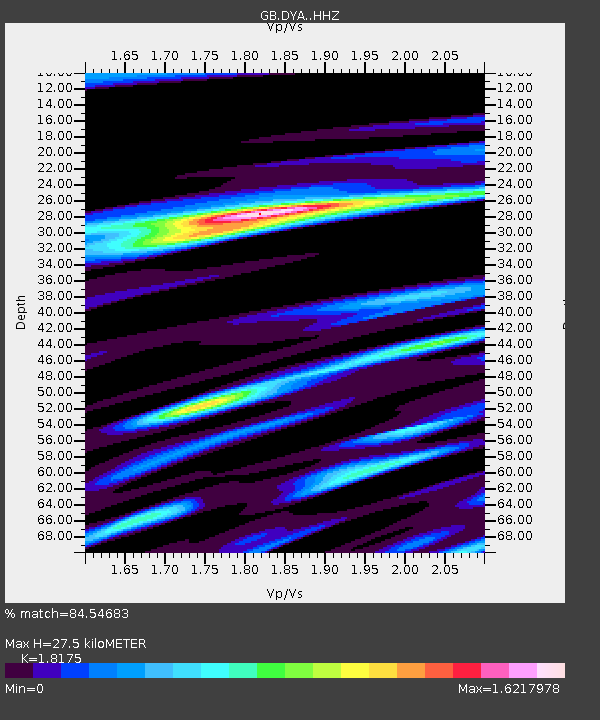
| Estimated Moho Depth: |
27.5 km |
| Estimated Crust Vp/Vs: |
1.82 |
| Assumed Crust Vp: |
6.182 km/s |
| Estimated Crust Vs: |
3.402 km/s |
| Estimated Crust Poisson's Ratio: |
0.28 |
|
| Radial Match: |
84.54683 % |
| Radial Bump: |
400 |
| Transverse Match: |
65.20269 % |
| Transverse Bump: |
400 |
| SOD ConfigId: |
25131211 |
| Insert Time: |
2021-07-24 02:26:23.728 +0000 |
| GWidth: |
2.5 |
| Max Bumps: |
400 |
| Tol: |
0.001 |
|

Signal To Noise
| Channel | StoN | STA | LTA |
| GB:DYA: :HHZ:20210710T02:23:21.860026Z | 3.7641628 | 5.821769E-7 | 1.5466304E-7 |
| GB:DYA: :HHN:20210710T02:23:21.860026Z | 1.099623 | 1.4691591E-7 | 1.3360572E-7 |
| GB:DYA: :HHE:20210710T02:23:21.860026Z | 3.094359 | 3.8668261E-7 | 1.2496372E-7 |
| Arrivals |
| Ps | 3.8 SECOND |
| PpPs | 12 SECOND |
| PsPs/PpSs | 16 SECOND |


