You are here: Home > Network List > OE - Austrian Seismic Network Stations List
> Station ARSA Arzberg, Steiermark, Austria > Earthquake Result Viewer
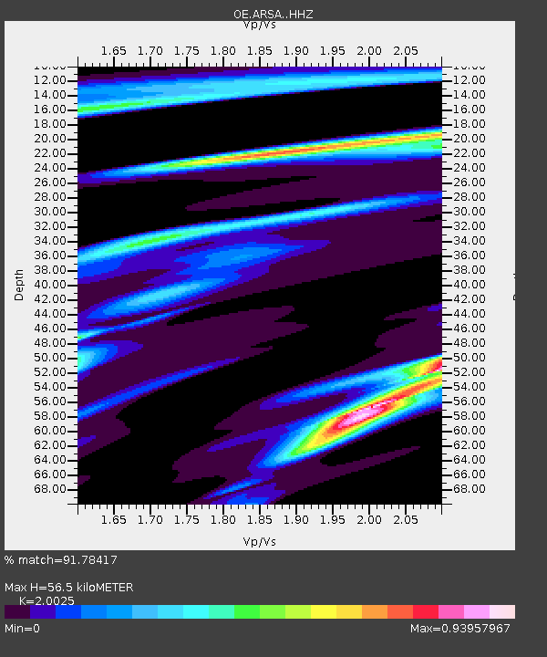
ARSA Arzberg, Steiermark, Austria - Earthquake Result Viewer
| Earthquake location: |
Afghanistan-Tajikistan Bord Reg. |
| Earthquake latitude/longitude: |
39.0/70.6 |
| Earthquake time(UTC): |
2021/07/10 (191) 02:14:43 GMT |
| Earthquake Depth: |
17 km |
| Earthquake Magnitude: |
5.8 Mww |
| Earthquake Catalog/Contributor: |
NEIC PDE/us |
|
| Network: |
OE Austrian Seismic Network |
| Station: |
ARSA Arzberg, Steiermark, Austria |
| Lat/Lon: |
47.25 N/15.52 E |
| Elevation: |
577 m |
|
| Distance: |
40.3 deg |
| Az: |
300.305 deg |
| Baz: |
81.138 deg |
| Ray Param: |
0.07446693 |
| Estimated Moho Depth: |
56.5 km |
| Estimated Crust Vp/Vs: |
2.00 |
| Assumed Crust Vp: |
6.419 km/s |
| Estimated Crust Vs: |
3.206 km/s |
| Estimated Crust Poisson's Ratio: |
0.33 |
|
| Radial Match: |
91.78417 % |
| Radial Bump: |
181 |
| Transverse Match: |
68.20428 % |
| Transverse Bump: |
400 |
| SOD ConfigId: |
25131211 |
| Insert Time: |
2021-07-24 02:30:08.902 +0000 |
| GWidth: |
2.5 |
| Max Bumps: |
400 |
| Tol: |
0.001 |
|

Signal To Noise
| Channel | StoN | STA | LTA |
| OE:ARSA: :HHZ:20210710T02:21:49.358012Z | 5.1140594 | 3.1143435E-7 | 6.089768E-8 |
| OE:ARSA: :HHN:20210710T02:21:49.358012Z | 2.4319828 | 8.602219E-8 | 3.5371215E-8 |
| OE:ARSA: :HHE:20210710T02:21:49.358012Z | 5.045396 | 2.2060138E-7 | 4.3723304E-8 |
| Arrivals |
| Ps | 9.4 SECOND |
| PpPs | 25 SECOND |
| PsPs/PpSs | 34 SECOND |


