You are here: Home > Network List > OE - Austrian Seismic Network Stations List
> Station KBA Koelnbreinsperre, Kaernten, Austria > Earthquake Result Viewer
KBA Koelnbreinsperre, Kaernten, Austria - Earthquake Result Viewer
| Earthquake location: |
Afghanistan-Tajikistan Bord Reg. |
| Earthquake latitude/longitude: |
39.0/70.6 |
| Earthquake time(UTC): |
2021/07/10 (191) 02:14:43 GMT |
| Earthquake Depth: |
17 km |
| Earthquake Magnitude: |
5.8 Mww |
| Earthquake Catalog/Contributor: |
NEIC PDE/us |
|
| Network: |
OE Austrian Seismic Network |
| Station: |
KBA Koelnbreinsperre, Kaernten, Austria |
| Lat/Lon: |
47.08 N/13.34 E |
| Elevation: |
1721 m |
|
| Distance: |
41.8 deg |
| Az: |
300.425 deg |
| Baz: |
79.636 deg |
| Ray Param: |
0.07355197 |
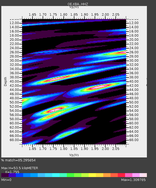
| Estimated Moho Depth: |
53.5 km |
| Estimated Crust Vp/Vs: |
1.75 |
| Assumed Crust Vp: |
6.35 km/s |
| Estimated Crust Vs: |
3.618 km/s |
| Estimated Crust Poisson's Ratio: |
0.26 |
|
| Radial Match: |
85.295654 % |
| Radial Bump: |
340 |
| Transverse Match: |
72.6881 % |
| Transverse Bump: |
400 |
| SOD ConfigId: |
25131211 |
| Insert Time: |
2021-07-24 02:30:12.444 +0000 |
| GWidth: |
2.5 |
| Max Bumps: |
400 |
| Tol: |
0.001 |
|

Signal To Noise
| Channel | StoN | STA | LTA |
| OE:KBA: :HHZ:20210710T02:22:01.64799Z | 6.1857815 | 4.2926084E-7 | 6.939476E-8 |
| OE:KBA: :HHN:20210710T02:22:01.64799Z | 3.2727134 | 1.2939287E-7 | 3.9536882E-8 |
| OE:KBA: :HHE:20210710T02:22:01.64799Z | 3.8171432 | 2.7929644E-7 | 7.316897E-8 |
| Arrivals |
| Ps | 6.8 SECOND |
| PpPs | 22 SECOND |
| PsPs/PpSs | 29 SECOND |


