You are here: Home > Network List > WI - West Indies IPGP Network Stations List
> Station CBE Capesterre Belles-Eaux, Guadeloupe > Earthquake Result Viewer
CBE Capesterre Belles-Eaux, Guadeloupe - Earthquake Result Viewer
| Earthquake location: |
Near Coast Of Peru |
| Earthquake latitude/longitude: |
-15.8/-74.7 |
| Earthquake time(UTC): |
2018/01/14 (014) 09:18:45 GMT |
| Earthquake Depth: |
36 km |
| Earthquake Magnitude: |
7.1 mww |
| Earthquake Catalog/Contributor: |
NEIC PDE/us |
|
| Network: |
WI West Indies IPGP Network |
| Station: |
CBE Capesterre Belles-Eaux, Guadeloupe |
| Lat/Lon: |
16.07 N/61.61 W |
| Elevation: |
380 m |
|
| Distance: |
34.2 deg |
| Az: |
22.874 deg |
| Baz: |
202.909 deg |
| Ray Param: |
0.07779778 |
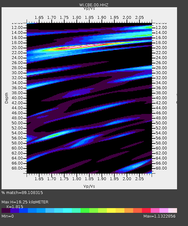
| Estimated Moho Depth: |
19.25 km |
| Estimated Crust Vp/Vs: |
1.82 |
| Assumed Crust Vp: |
6.048 km/s |
| Estimated Crust Vs: |
3.332 km/s |
| Estimated Crust Poisson's Ratio: |
0.28 |
|
| Radial Match: |
89.108315 % |
| Radial Bump: |
400 |
| Transverse Match: |
75.45552 % |
| Transverse Bump: |
400 |
| SOD ConfigId: |
2537391 |
| Insert Time: |
2018-01-28 09:26:49.913 +0000 |
| GWidth: |
2.5 |
| Max Bumps: |
400 |
| Tol: |
0.001 |
|

Signal To Noise
| Channel | StoN | STA | LTA |
| WI:CBE:00:HHZ:20180114T09:24:56.730004Z | 12.91635 | 1.1643961E-5 | 9.014901E-7 |
| WI:CBE:00:HHN:20180114T09:24:56.730004Z | 5.955937 | 7.708505E-6 | 1.2942556E-6 |
| WI:CBE:00:HHE:20180114T09:24:56.730004Z | 3.0705538 | 3.94028E-6 | 1.2832472E-6 |
| Arrivals |
| Ps | 2.8 SECOND |
| PpPs | 8.4 SECOND |
| PsPs/PpSs | 11 SECOND |


