You are here: Home > Network List > WY - Yellowstone Wyoming Seismic Network Stations List
> Station YMP Mirror Lake Plateau, YNP, WY, USA > Earthquake Result Viewer
YMP Mirror Lake Plateau, YNP, WY, USA - Earthquake Result Viewer
| Earthquake location: |
Near Coast Of Peru |
| Earthquake latitude/longitude: |
-15.8/-74.7 |
| Earthquake time(UTC): |
2018/01/14 (014) 09:18:45 GMT |
| Earthquake Depth: |
36 km |
| Earthquake Magnitude: |
7.1 mww |
| Earthquake Catalog/Contributor: |
NEIC PDE/us |
|
| Network: |
WY Yellowstone Wyoming Seismic Network |
| Station: |
YMP Mirror Lake Plateau, YNP, WY, USA |
| Lat/Lon: |
44.74 N/110.16 W |
| Elevation: |
2774 m |
|
| Distance: |
68.3 deg |
| Az: |
333.612 deg |
| Baz: |
143.099 deg |
| Ray Param: |
0.056332495 |
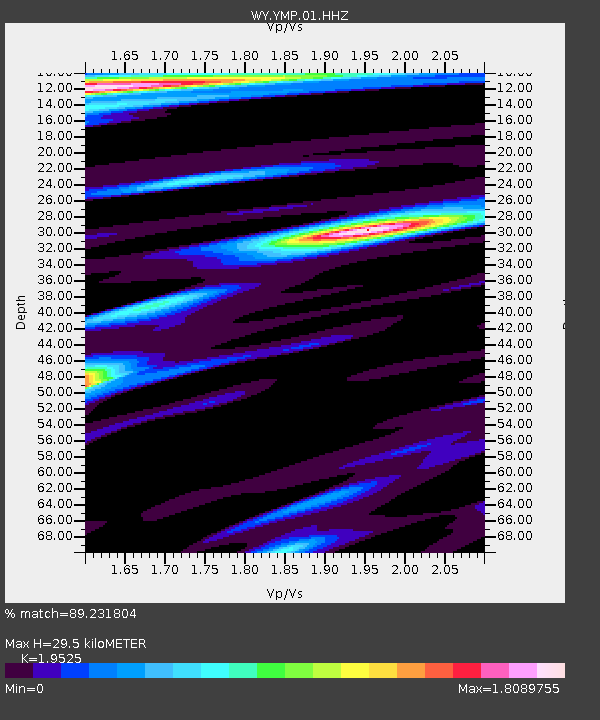
| Estimated Moho Depth: |
29.5 km |
| Estimated Crust Vp/Vs: |
1.95 |
| Assumed Crust Vp: |
6.35 km/s |
| Estimated Crust Vs: |
3.252 km/s |
| Estimated Crust Poisson's Ratio: |
0.32 |
|
| Radial Match: |
89.231804 % |
| Radial Bump: |
400 |
| Transverse Match: |
89.225426 % |
| Transverse Bump: |
400 |
| SOD ConfigId: |
2537391 |
| Insert Time: |
2018-01-28 09:27:06.048 +0000 |
| GWidth: |
2.5 |
| Max Bumps: |
400 |
| Tol: |
0.001 |
|

Signal To Noise
| Channel | StoN | STA | LTA |
| WY:YMP:01:HHZ:20180114T09:29:11.608025Z | 23.969412 | 1.3540476E-7 | 5.6490648E-9 |
| WY:YMP:01:HHN:20180114T09:29:11.608025Z | 5.054273 | 5.2773665E-8 | 1.0441395E-8 |
| WY:YMP:01:HHE:20180114T09:29:11.608025Z | 6.7050138 | 4.7653113E-8 | 7.107087E-9 |
| Arrivals |
| Ps | 4.6 SECOND |
| PpPs | 13 SECOND |
| PsPs/PpSs | 18 SECOND |


