You are here: Home > Network List > WY - Yellowstone Wyoming Seismic Network Stations List
> Station YHH Holmes Hill, YNP, WY, USA > Earthquake Result Viewer
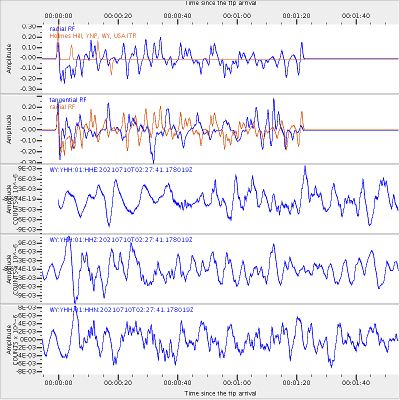
YHH Holmes Hill, YNP, WY, USA - Earthquake Result Viewer
*The percent match for this event was below the threshold and hence no stack was calculated.
| Earthquake location: |
Afghanistan-Tajikistan Bord Reg. |
| Earthquake latitude/longitude: |
39.0/70.6 |
| Earthquake time(UTC): |
2021/07/10 (191) 02:14:43 GMT |
| Earthquake Depth: |
17 km |
| Earthquake Magnitude: |
5.8 Mww |
| Earthquake Catalog/Contributor: |
NEIC PDE/us |
|
| Network: |
WY Yellowstone Wyoming Seismic Network |
| Station: |
YHH Holmes Hill, YNP, WY, USA |
| Lat/Lon: |
44.79 N/110.85 W |
| Elevation: |
2717 m |
|
| Distance: |
96.6 deg |
| Az: |
1.02 deg |
| Baz: |
358.883 deg |
| Ray Param: |
$rayparam |
*The percent match for this event was below the threshold and hence was not used in the summary stack. |
|
| Radial Match: |
56.69988 % |
| Radial Bump: |
400 |
| Transverse Match: |
53.20283 % |
| Transverse Bump: |
400 |
| SOD ConfigId: |
25131211 |
| Insert Time: |
2021-07-24 02:35:27.197 +0000 |
| GWidth: |
2.5 |
| Max Bumps: |
400 |
| Tol: |
0.001 |
|
Signal To Noise
| Channel | StoN | STA | LTA |
| WY:YHH:01:HHZ:20210710T02:27:41.178019Z | 2.2101266 | 6.151592E-9 | 2.7833664E-9 |
| WY:YHH:01:HHN:20210710T02:27:41.178019Z | 1.3294305 | 2.93578E-9 | 2.208299E-9 |
| WY:YHH:01:HHE:20210710T02:27:41.178019Z | 0.723101 | 2.1480366E-9 | 2.97059E-9 |
| Arrivals |
| Ps | |
| PpPs | |
| PsPs/PpSs | |


