You are here: Home > Network List > CI - Caltech Regional Seismic Network Stations List
> Station VES Vestal, Richgrove, CA, USA > Earthquake Result Viewer
VES Vestal, Richgrove, CA, USA - Earthquake Result Viewer
| Earthquake location: |
Andreanof Islands, Aleutian Is. |
| Earthquake latitude/longitude: |
51.8/-176.0 |
| Earthquake time(UTC): |
2021/07/11 (192) 17:04:37 GMT |
| Earthquake Depth: |
60 km |
| Earthquake Magnitude: |
4.9 Mww |
| Earthquake Catalog/Contributor: |
NEIC PDE/us |
|
| Network: |
CI Caltech Regional Seismic Network |
| Station: |
VES Vestal, Richgrove, CA, USA |
| Lat/Lon: |
35.84 N/119.08 W |
| Elevation: |
154 m |
|
| Distance: |
42.9 deg |
| Az: |
88.797 deg |
| Baz: |
310.128 deg |
| Ray Param: |
0.07273022 |
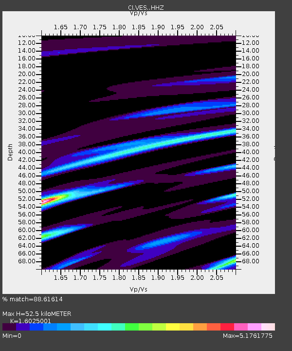
| Estimated Moho Depth: |
52.5 km |
| Estimated Crust Vp/Vs: |
1.60 |
| Assumed Crust Vp: |
6.1 km/s |
| Estimated Crust Vs: |
3.807 km/s |
| Estimated Crust Poisson's Ratio: |
0.18 |
|
| Radial Match: |
88.61614 % |
| Radial Bump: |
248 |
| Transverse Match: |
86.70999 % |
| Transverse Bump: |
300 |
| SOD ConfigId: |
25131211 |
| Insert Time: |
2021-07-25 17:08:23.603 +0000 |
| GWidth: |
2.5 |
| Max Bumps: |
400 |
| Tol: |
0.001 |
|

Signal To Noise
| Channel | StoN | STA | LTA |
| CI:VES: :HHZ:20210711T17:11:59.267996Z | 2.1097565 | 4.10605E-7 | 1.9462199E-7 |
| CI:VES: :HHN:20210711T17:11:59.267996Z | 0.5216808 | 4.458251E-7 | 8.5459374E-7 |
| CI:VES: :HHE:20210711T17:11:59.267996Z | 3.8143346 | 1.8903825E-6 | 4.955995E-7 |
| Arrivals |
| Ps | 5.5 SECOND |
| PpPs | 21 SECOND |
| PsPs/PpSs | 27 SECOND |


