You are here: Home > Network List > WY - Yellowstone Wyoming Seismic Network Stations List
> Station YHH Holmes Hill, YNP, WY, USA > Earthquake Result Viewer
YHH Holmes Hill, YNP, WY, USA - Earthquake Result Viewer
*The percent match for this event was below the threshold and hence no stack was calculated.
| Earthquake location: |
Andreanof Islands, Aleutian Is. |
| Earthquake latitude/longitude: |
51.8/-176.0 |
| Earthquake time(UTC): |
2021/07/11 (192) 17:04:37 GMT |
| Earthquake Depth: |
60 km |
| Earthquake Magnitude: |
4.9 Mww |
| Earthquake Catalog/Contributor: |
NEIC PDE/us |
|
| Network: |
WY Yellowstone Wyoming Seismic Network |
| Station: |
YHH Holmes Hill, YNP, WY, USA |
| Lat/Lon: |
44.79 N/110.85 W |
| Elevation: |
2717 m |
|
| Distance: |
42.6 deg |
| Az: |
72.682 deg |
| Baz: |
303.583 deg |
| Ray Param: |
$rayparam |
*The percent match for this event was below the threshold and hence was not used in the summary stack. |
|
| Radial Match: |
56.89603 % |
| Radial Bump: |
400 |
| Transverse Match: |
65.34493 % |
| Transverse Bump: |
400 |
| SOD ConfigId: |
25131211 |
| Insert Time: |
2021-07-25 17:24:49.363 +0000 |
| GWidth: |
2.5 |
| Max Bumps: |
400 |
| Tol: |
0.001 |
|
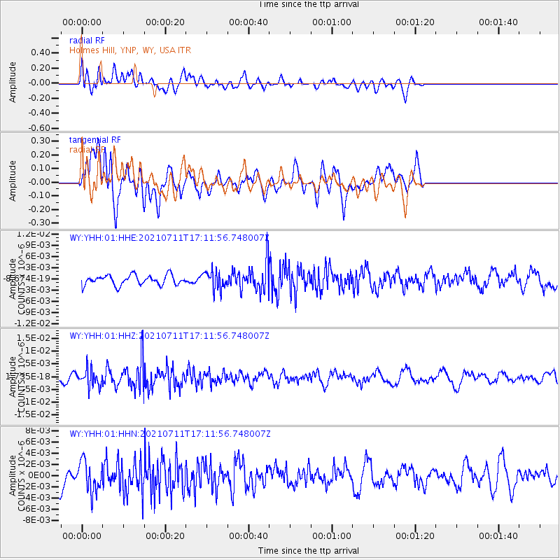
Signal To Noise
| Channel | StoN | STA | LTA |
| WY:YHH:01:HHZ:20210711T17:11:56.748007Z | 1.8429571 | 3.353954E-9 | 1.8198764E-9 |
| WY:YHH:01:HHN:20210711T17:11:56.748007Z | 1.645466 | 2.8012828E-9 | 1.7024253E-9 |
| WY:YHH:01:HHE:20210711T17:11:56.748007Z | 1.8067055 | 2.4040183E-9 | 1.330609E-9 |
| Arrivals |
| Ps | |
| PpPs | |
| PsPs/PpSs | |


