You are here: Home > Network List > AG - Arkansas Seismic Network Stations List
> Station U40A Yellville, AR > Earthquake Result Viewer
U40A Yellville, AR - Earthquake Result Viewer
| Earthquake location: |
Kuril Islands |
| Earthquake latitude/longitude: |
46.2/151.7 |
| Earthquake time(UTC): |
2021/07/13 (194) 00:30:16 GMT |
| Earthquake Depth: |
33 km |
| Earthquake Magnitude: |
5.6 Mww |
| Earthquake Catalog/Contributor: |
NEIC PDE/us |
|
| Network: |
AG Arkansas Seismic Network |
| Station: |
U40A Yellville, AR |
| Lat/Lon: |
36.36 N/92.85 W |
| Elevation: |
374 m |
|
| Distance: |
79.5 deg |
| Az: |
47.83 deg |
| Baz: |
320.36 deg |
| Ray Param: |
0.04890965 |
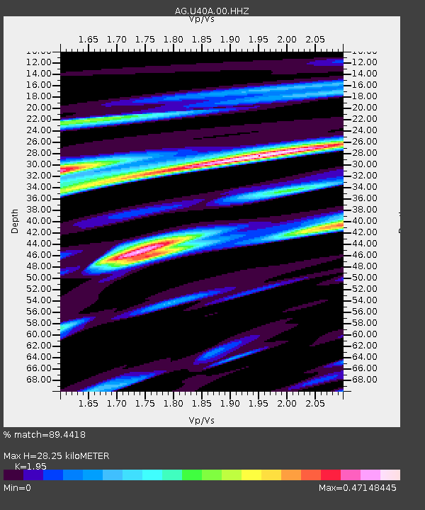
| Estimated Moho Depth: |
28.25 km |
| Estimated Crust Vp/Vs: |
1.95 |
| Assumed Crust Vp: |
6.53 km/s |
| Estimated Crust Vs: |
3.349 km/s |
| Estimated Crust Poisson's Ratio: |
0.32 |
|
| Radial Match: |
89.4418 % |
| Radial Bump: |
400 |
| Transverse Match: |
71.94348 % |
| Transverse Bump: |
368 |
| SOD ConfigId: |
25131211 |
| Insert Time: |
2021-07-27 00:31:16.801 +0000 |
| GWidth: |
2.5 |
| Max Bumps: |
400 |
| Tol: |
0.001 |
|
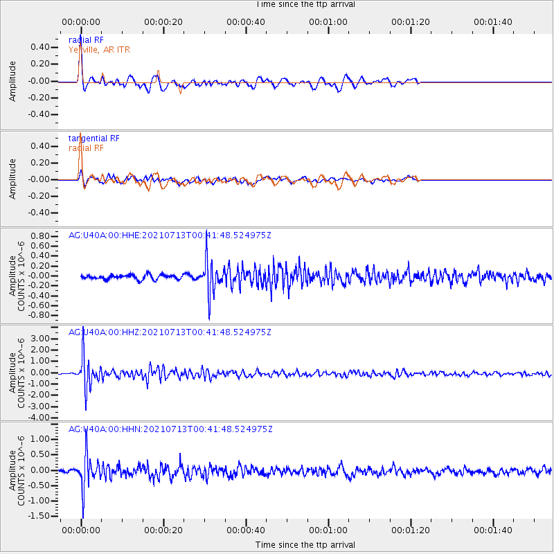
Signal To Noise
| Channel | StoN | STA | LTA |
| AG:U40A:00:HHZ:20210713T00:41:48.524975Z | 20.418453 | 1.3456316E-6 | 6.590272E-8 |
| AG:U40A:00:HHN:20210713T00:41:48.524975Z | 8.90141 | 5.2694145E-7 | 5.919753E-8 |
| AG:U40A:00:HHE:20210713T00:41:48.524975Z | 7.4034886 | 3.3034934E-7 | 4.4620766E-8 |
| Arrivals |
| Ps | 4.2 SECOND |
| PpPs | 12 SECOND |
| PsPs/PpSs | 17 SECOND |


