You are here: Home > Network List > IU - Global Seismograph Network (GSN - IRIS/USGS) Stations List
> Station JOHN Johnston Island, USA > Earthquake Result Viewer
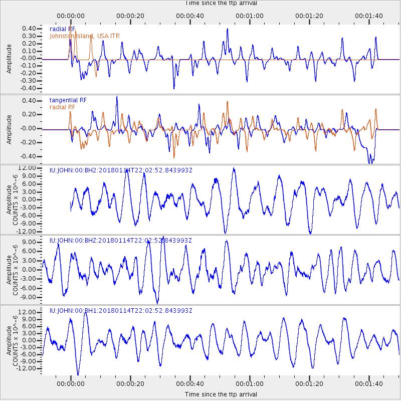
JOHN Johnston Island, USA - Earthquake Result Viewer
*The percent match for this event was below the threshold and hence no stack was calculated.
| Earthquake location: |
Near N Coast Of New Guinea, P.N.G. |
| Earthquake latitude/longitude: |
-4.8/144.9 |
| Earthquake time(UTC): |
2018/01/14 (014) 21:54:36 GMT |
| Earthquake Depth: |
65 km |
| Earthquake Magnitude: |
5.5 Mww |
| Earthquake Catalog/Contributor: |
NEIC PDE/us |
|
| Network: |
IU Global Seismograph Network (GSN - IRIS/USGS) |
| Station: |
JOHN Johnston Island, USA |
| Lat/Lon: |
16.73 N/169.53 W |
| Elevation: |
2.0 m |
|
| Distance: |
49.9 deg |
| Az: |
63.518 deg |
| Baz: |
248.576 deg |
| Ray Param: |
$rayparam |
*The percent match for this event was below the threshold and hence was not used in the summary stack. |
|
| Radial Match: |
44.10527 % |
| Radial Bump: |
400 |
| Transverse Match: |
63.69438 % |
| Transverse Bump: |
400 |
| SOD ConfigId: |
2537391 |
| Insert Time: |
2018-01-28 21:55:30.134 +0000 |
| GWidth: |
2.5 |
| Max Bumps: |
400 |
| Tol: |
0.001 |
|
Signal To Noise
| Channel | StoN | STA | LTA |
| IU:JOHN:00:BHZ:20180114T22:02:52.843993Z | 1.2009343 | 3.2849143E-6 | 2.7352992E-6 |
| IU:JOHN:00:BH1:20180114T22:02:52.843993Z | 1.6672511 | 8.346936E-6 | 5.006406E-6 |
| IU:JOHN:00:BH2:20180114T22:02:52.843993Z | 0.3605514 | 1.7841954E-6 | 4.948519E-6 |
| Arrivals |
| Ps | |
| PpPs | |
| PsPs/PpSs | |


