You are here: Home > Network List > AK - Alaska Regional Network Stations List
> Station H23K Yukon River, AK, USA > Earthquake Result Viewer
H23K Yukon River, AK, USA - Earthquake Result Viewer
| Earthquake location: |
Kuril Islands |
| Earthquake latitude/longitude: |
46.2/151.7 |
| Earthquake time(UTC): |
2021/07/13 (194) 00:30:16 GMT |
| Earthquake Depth: |
33 km |
| Earthquake Magnitude: |
5.6 Mww |
| Earthquake Catalog/Contributor: |
NEIC PDE/us |
|
| Network: |
AK Alaska Regional Network |
| Station: |
H23K Yukon River, AK, USA |
| Lat/Lon: |
65.83 N/149.54 W |
| Elevation: |
617 m |
|
| Distance: |
36.5 deg |
| Az: |
36.287 deg |
| Baz: |
266.937 deg |
| Ray Param: |
0.07660067 |
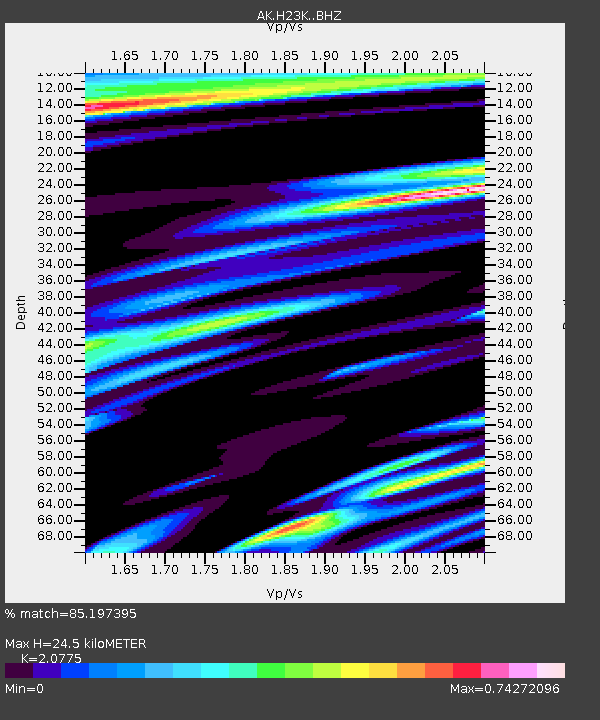
| Estimated Moho Depth: |
24.5 km |
| Estimated Crust Vp/Vs: |
2.08 |
| Assumed Crust Vp: |
6.566 km/s |
| Estimated Crust Vs: |
3.161 km/s |
| Estimated Crust Poisson's Ratio: |
0.35 |
|
| Radial Match: |
85.197395 % |
| Radial Bump: |
400 |
| Transverse Match: |
70.88863 % |
| Transverse Bump: |
400 |
| SOD ConfigId: |
25131211 |
| Insert Time: |
2021-07-27 00:32:56.007 +0000 |
| GWidth: |
2.5 |
| Max Bumps: |
400 |
| Tol: |
0.001 |
|

Signal To Noise
| Channel | StoN | STA | LTA |
| AK:H23K: :BHZ:20210713T00:36:48.560009Z | 12.900245 | 1.0549398E-6 | 8.177673E-8 |
| AK:H23K: :BHN:20210713T00:36:48.560009Z | 1.5689089 | 1.3487295E-7 | 8.596608E-8 |
| AK:H23K: :BHE:20210713T00:36:48.560009Z | 8.472321 | 5.3554686E-7 | 6.321135E-8 |
| Arrivals |
| Ps | 4.3 SECOND |
| PpPs | 11 SECOND |
| PsPs/PpSs | 15 SECOND |


