You are here: Home > Network List > IU - Global Seismograph Network (GSN - IRIS/USGS) Stations List
> Station XMAS Kiritimati Island, Republic of Kiribati > Earthquake Result Viewer
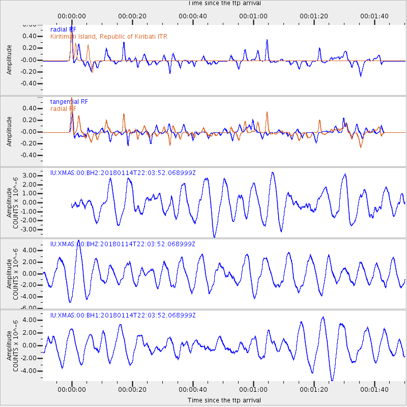
XMAS Kiritimati Island, Republic of Kiribati - Earthquake Result Viewer
*The percent match for this event was below the threshold and hence no stack was calculated.
| Earthquake location: |
Near N Coast Of New Guinea, P.N.G. |
| Earthquake latitude/longitude: |
-4.8/144.9 |
| Earthquake time(UTC): |
2018/01/14 (014) 21:54:36 GMT |
| Earthquake Depth: |
65 km |
| Earthquake Magnitude: |
5.5 Mww |
| Earthquake Catalog/Contributor: |
NEIC PDE/us |
|
| Network: |
IU Global Seismograph Network (GSN - IRIS/USGS) |
| Station: |
XMAS Kiritimati Island, Republic of Kiribati |
| Lat/Lon: |
2.04 N/157.45 W |
| Elevation: |
20 m |
|
| Distance: |
58.0 deg |
| Az: |
84.604 deg |
| Baz: |
263.096 deg |
| Ray Param: |
$rayparam |
*The percent match for this event was below the threshold and hence was not used in the summary stack. |
|
| Radial Match: |
60.116615 % |
| Radial Bump: |
400 |
| Transverse Match: |
45.478966 % |
| Transverse Bump: |
400 |
| SOD ConfigId: |
2537391 |
| Insert Time: |
2018-01-28 21:55:42.108 +0000 |
| GWidth: |
2.5 |
| Max Bumps: |
400 |
| Tol: |
0.001 |
|
Signal To Noise
| Channel | StoN | STA | LTA |
| IU:XMAS:00:BHZ:20180114T22:03:52.068999Z | 3.0918403 | 3.7635136E-6 | 1.2172407E-6 |
| IU:XMAS:00:BH1:20180114T22:03:52.068999Z | 1.5060618 | 1.9607305E-6 | 1.3018924E-6 |
| IU:XMAS:00:BH2:20180114T22:03:52.068999Z | 0.70146513 | 8.8696197E-7 | 1.264442E-6 |
| Arrivals |
| Ps | |
| PpPs | |
| PsPs/PpSs | |


