You are here: Home > Network List > AV - Alaska Volcano Observatory Stations List
> Station PLBL Mt. Peulik Volcano, Alaska > Earthquake Result Viewer
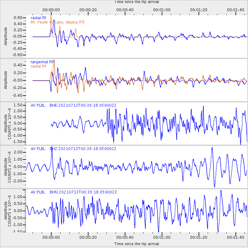
PLBL Mt. Peulik Volcano, Alaska - Earthquake Result Viewer
*The percent match for this event was below the threshold and hence no stack was calculated.
| Earthquake location: |
Kuril Islands |
| Earthquake latitude/longitude: |
46.2/151.7 |
| Earthquake time(UTC): |
2021/07/13 (194) 00:30:16 GMT |
| Earthquake Depth: |
33 km |
| Earthquake Magnitude: |
5.6 Mww |
| Earthquake Catalog/Contributor: |
NEIC PDE/us |
|
| Network: |
AV Alaska Volcano Observatory |
| Station: |
PLBL Mt. Peulik Volcano, Alaska |
| Lat/Lon: |
57.70 N/156.82 W |
| Elevation: |
461 m |
|
| Distance: |
33.0 deg |
| Az: |
50.546 deg |
| Baz: |
272.257 deg |
| Ray Param: |
$rayparam |
*The percent match for this event was below the threshold and hence was not used in the summary stack. |
|
| Radial Match: |
75.50334 % |
| Radial Bump: |
400 |
| Transverse Match: |
62.391136 % |
| Transverse Bump: |
400 |
| SOD ConfigId: |
25131211 |
| Insert Time: |
2021-07-27 00:36:14.728 +0000 |
| GWidth: |
2.5 |
| Max Bumps: |
400 |
| Tol: |
0.001 |
|
Signal To Noise
| Channel | StoN | STA | LTA |
| AV:PLBL: :BHZ:20210713T00:36:18.059002Z | 3.766057 | 1.1472345E-6 | 3.0462482E-7 |
| AV:PLBL: :BHN:20210713T00:36:18.059002Z | 1.331763 | 4.842408E-7 | 3.6360885E-7 |
| AV:PLBL: :BHE:20210713T00:36:18.059002Z | 2.6879048 | 6.5668365E-7 | 2.4431063E-7 |
| Arrivals |
| Ps | |
| PpPs | |
| PsPs/PpSs | |


