You are here: Home > Network List > AV - Alaska Volcano Observatory Stations List
> Station SPCR Ckakachatna River, Mount Spurr, Alaska > Earthquake Result Viewer
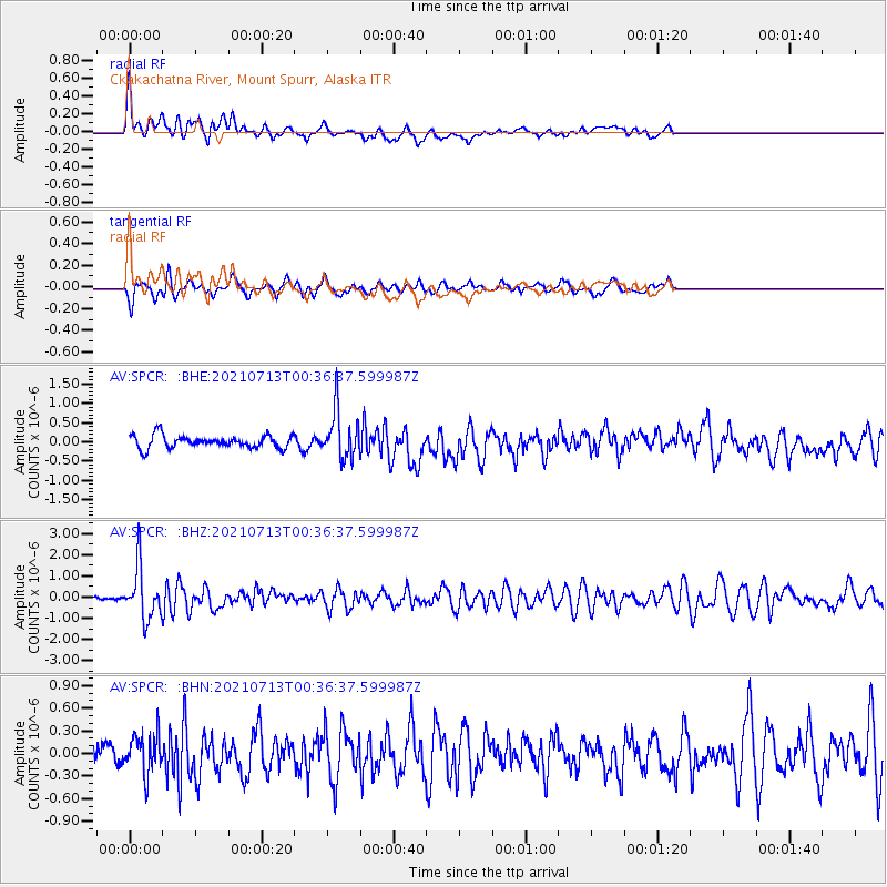
SPCR Ckakachatna River, Mount Spurr, Alaska - Earthquake Result Viewer
*The percent match for this event was below the threshold and hence no stack was calculated.
| Earthquake location: |
Kuril Islands |
| Earthquake latitude/longitude: |
46.2/151.7 |
| Earthquake time(UTC): |
2021/07/13 (194) 00:30:16 GMT |
| Earthquake Depth: |
33 km |
| Earthquake Magnitude: |
5.6 Mww |
| Earthquake Catalog/Contributor: |
NEIC PDE/us |
|
| Network: |
AV Alaska Volcano Observatory |
| Station: |
SPCR Ckakachatna River, Mount Spurr, Alaska |
| Lat/Lon: |
61.20 N/152.21 W |
| Elevation: |
984 m |
|
| Distance: |
35.2 deg |
| Az: |
44.171 deg |
| Baz: |
270.944 deg |
| Ray Param: |
$rayparam |
*The percent match for this event was below the threshold and hence was not used in the summary stack. |
|
| Radial Match: |
67.91709 % |
| Radial Bump: |
400 |
| Transverse Match: |
70.14043 % |
| Transverse Bump: |
400 |
| SOD ConfigId: |
25131211 |
| Insert Time: |
2021-07-27 00:36:31.551 +0000 |
| GWidth: |
2.5 |
| Max Bumps: |
400 |
| Tol: |
0.001 |
|
Signal To Noise
| Channel | StoN | STA | LTA |
| AV:SPCR: :BHZ:20210713T00:36:37.599987Z | 10.944766 | 1.186387E-6 | 1.0839765E-7 |
| AV:SPCR: :BHN:20210713T00:36:37.599987Z | 2.3444817 | 2.590353E-7 | 1.10487235E-7 |
| AV:SPCR: :BHE:20210713T00:36:37.599987Z | 3.8148482 | 6.268278E-7 | 1.6431265E-7 |
| Arrivals |
| Ps | |
| PpPs | |
| PsPs/PpSs | |


