You are here: Home > Network List > AZ - ANZA Regional Network Stations List
> Station LVA2 AZ.LVA2 > Earthquake Result Viewer
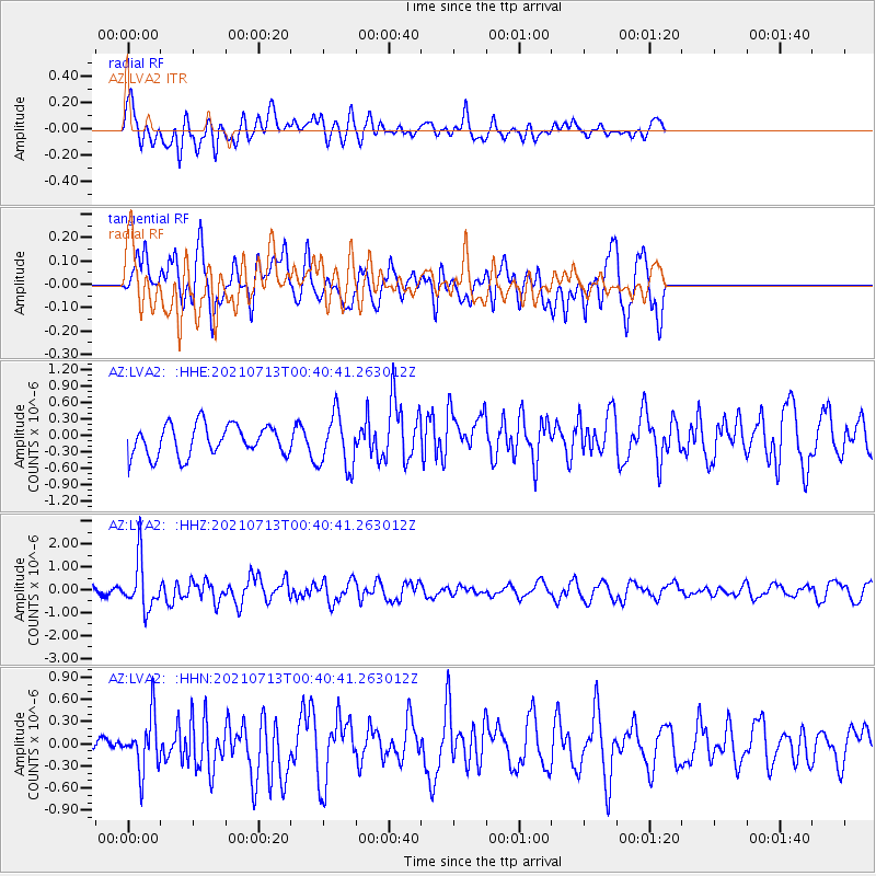
LVA2 AZ.LVA2 - Earthquake Result Viewer
*The percent match for this event was below the threshold and hence no stack was calculated.
| Earthquake location: |
Kuril Islands |
| Earthquake latitude/longitude: |
46.2/151.7 |
| Earthquake time(UTC): |
2021/07/13 (194) 00:30:16 GMT |
| Earthquake Depth: |
33 km |
| Earthquake Magnitude: |
5.6 Mww |
| Earthquake Catalog/Contributor: |
NEIC PDE/us |
|
| Network: |
AZ ANZA Regional Network |
| Station: |
LVA2 AZ.LVA2 |
| Lat/Lon: |
33.35 N/116.56 W |
| Elevation: |
1435 m |
|
| Distance: |
68.0 deg |
| Az: |
64.503 deg |
| Baz: |
311.47 deg |
| Ray Param: |
$rayparam |
*The percent match for this event was below the threshold and hence was not used in the summary stack. |
|
| Radial Match: |
55.775932 % |
| Radial Bump: |
400 |
| Transverse Match: |
60.570187 % |
| Transverse Bump: |
400 |
| SOD ConfigId: |
25131211 |
| Insert Time: |
2021-07-27 00:36:43.789 +0000 |
| GWidth: |
2.5 |
| Max Bumps: |
400 |
| Tol: |
0.001 |
|
Signal To Noise
| Channel | StoN | STA | LTA |
| AZ:LVA2: :HHZ:20210713T00:40:41.263012Z | 4.5665965 | 1.0766929E-6 | 2.3577579E-7 |
| AZ:LVA2: :HHN:20210713T00:40:41.263012Z | 2.3935359 | 3.6357943E-7 | 1.5190055E-7 |
| AZ:LVA2: :HHE:20210713T00:40:41.263012Z | 1.7435826 | 4.857879E-7 | 2.7861478E-7 |
| Arrivals |
| Ps | |
| PpPs | |
| PsPs/PpSs | |


