You are here: Home > Network List > AZ - ANZA Regional Network Stations List
> Station SMER AZ.SMER > Earthquake Result Viewer
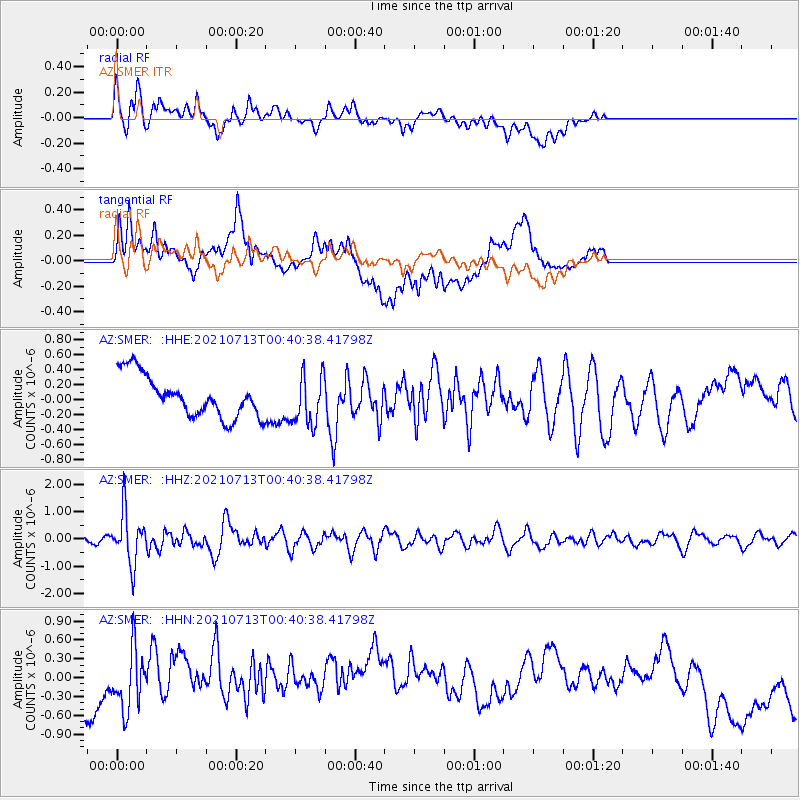
SMER AZ.SMER - Earthquake Result Viewer
*The percent match for this event was below the threshold and hence no stack was calculated.
| Earthquake location: |
Kuril Islands |
| Earthquake latitude/longitude: |
46.2/151.7 |
| Earthquake time(UTC): |
2021/07/13 (194) 00:30:16 GMT |
| Earthquake Depth: |
33 km |
| Earthquake Magnitude: |
5.6 Mww |
| Earthquake Catalog/Contributor: |
NEIC PDE/us |
|
| Network: |
AZ ANZA Regional Network |
| Station: |
SMER AZ.SMER |
| Lat/Lon: |
33.46 N/117.17 W |
| Elevation: |
355 m |
|
| Distance: |
67.5 deg |
| Az: |
64.781 deg |
| Baz: |
311.241 deg |
| Ray Param: |
$rayparam |
*The percent match for this event was below the threshold and hence was not used in the summary stack. |
|
| Radial Match: |
49.068516 % |
| Radial Bump: |
400 |
| Transverse Match: |
29.532618 % |
| Transverse Bump: |
400 |
| SOD ConfigId: |
25131211 |
| Insert Time: |
2021-07-27 00:36:50.609 +0000 |
| GWidth: |
2.5 |
| Max Bumps: |
400 |
| Tol: |
0.001 |
|
Signal To Noise
| Channel | StoN | STA | LTA |
| AZ:SMER: :HHZ:20210713T00:40:38.41798Z | 6.0582657 | 9.5269075E-7 | 1.5725469E-7 |
| AZ:SMER: :HHN:20210713T00:40:38.41798Z | 0.714739 | 4.840371E-7 | 6.7722215E-7 |
| AZ:SMER: :HHE:20210713T00:40:38.41798Z | 1.2328521 | 3.3755717E-7 | 2.7380182E-7 |
| Arrivals |
| Ps | |
| PpPs | |
| PsPs/PpSs | |


