You are here: Home > Network List > CC - Cascade Chain Volcano Monitoring Stations List
> Station CRBN Carbon River Ranger Station > Earthquake Result Viewer
CRBN Carbon River Ranger Station - Earthquake Result Viewer
| Earthquake location: |
Kuril Islands |
| Earthquake latitude/longitude: |
46.2/151.7 |
| Earthquake time(UTC): |
2021/07/13 (194) 00:30:16 GMT |
| Earthquake Depth: |
33 km |
| Earthquake Magnitude: |
5.6 Mww |
| Earthquake Catalog/Contributor: |
NEIC PDE/us |
|
| Network: |
CC Cascade Chain Volcano Monitoring |
| Station: |
CRBN Carbon River Ranger Station |
| Lat/Lon: |
46.99 N/121.96 W |
| Elevation: |
500 m |
|
| Distance: |
56.3 deg |
| Az: |
55.166 deg |
| Baz: |
303.582 deg |
| Ray Param: |
0.064148426 |
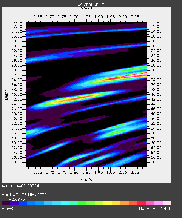
| Estimated Moho Depth: |
31.25 km |
| Estimated Crust Vp/Vs: |
2.09 |
| Assumed Crust Vp: |
6.597 km/s |
| Estimated Crust Vs: |
3.16 km/s |
| Estimated Crust Poisson's Ratio: |
0.35 |
|
| Radial Match: |
80.38934 % |
| Radial Bump: |
400 |
| Transverse Match: |
73.79637 % |
| Transverse Bump: |
400 |
| SOD ConfigId: |
25131211 |
| Insert Time: |
2021-07-27 00:38:22.346 +0000 |
| GWidth: |
2.5 |
| Max Bumps: |
400 |
| Tol: |
0.001 |
|

Signal To Noise
| Channel | StoN | STA | LTA |
| CC:CRBN: :BHZ:20210713T00:39:23.640026Z | 17.238508 | 1.27267E-6 | 7.382716E-8 |
| CC:CRBN: :BHN:20210713T00:39:23.640026Z | 5.020243 | 3.0227926E-7 | 6.021207E-8 |
| CC:CRBN: :BHE:20210713T00:39:23.640026Z | 4.247723 | 5.470103E-7 | 1.2877729E-7 |
| Arrivals |
| Ps | 5.4 SECOND |
| PpPs | 14 SECOND |
| PsPs/PpSs | 19 SECOND |


