You are here: Home > Network List > GS - US Geological Survey Networks Stations List
> Station DEC06 Boomer > Earthquake Result Viewer
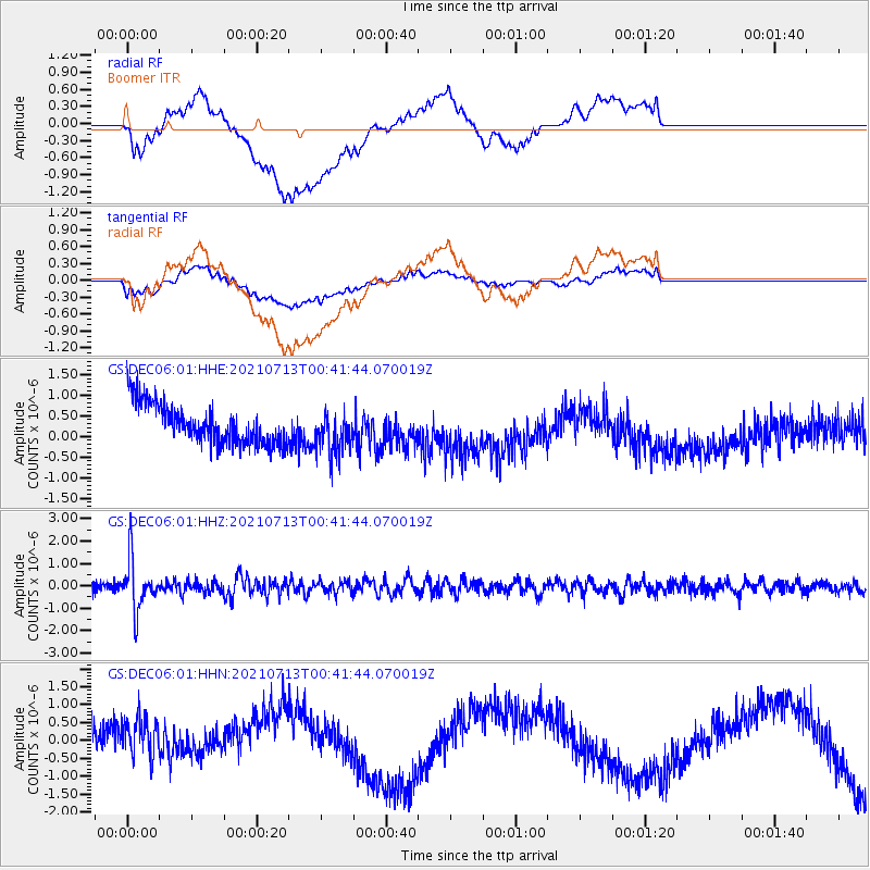
DEC06 Boomer - Earthquake Result Viewer
*The percent match for this event was below the threshold and hence no stack was calculated.
| Earthquake location: |
Kuril Islands |
| Earthquake latitude/longitude: |
46.2/151.7 |
| Earthquake time(UTC): |
2021/07/13 (194) 00:30:16 GMT |
| Earthquake Depth: |
33 km |
| Earthquake Magnitude: |
5.6 Mww |
| Earthquake Catalog/Contributor: |
NEIC PDE/us |
|
| Network: |
GS US Geological Survey Networks |
| Station: |
DEC06 Boomer |
| Lat/Lon: |
39.90 N/88.95 W |
| Elevation: |
215 m |
|
| Distance: |
78.6 deg |
| Az: |
43.128 deg |
| Baz: |
321.87 deg |
| Ray Param: |
$rayparam |
*The percent match for this event was below the threshold and hence was not used in the summary stack. |
|
| Radial Match: |
18.699026 % |
| Radial Bump: |
400 |
| Transverse Match: |
23.054708 % |
| Transverse Bump: |
400 |
| SOD ConfigId: |
25131211 |
| Insert Time: |
2021-07-27 00:45:46.759 +0000 |
| GWidth: |
2.5 |
| Max Bumps: |
400 |
| Tol: |
0.001 |
|
Signal To Noise
| Channel | StoN | STA | LTA |
| GS:DEC06:01:HHZ:20210713T00:41:44.070019Z | 7.5993166 | 1.1208456E-6 | 1.4749294E-7 |
| GS:DEC06:01:HHN:20210713T00:41:44.070019Z | 0.9370782 | 1.1155477E-6 | 1.1904532E-6 |
| GS:DEC06:01:HHE:20210713T00:41:44.070019Z | 1.0968049 | 5.374182E-7 | 4.899852E-7 |
| Arrivals |
| Ps | |
| PpPs | |
| PsPs/PpSs | |


