You are here: Home > Network List > IU - Global Seismograph Network (GSN - IRIS/USGS) Stations List
> Station JOHN Johnston Island, USA > Earthquake Result Viewer
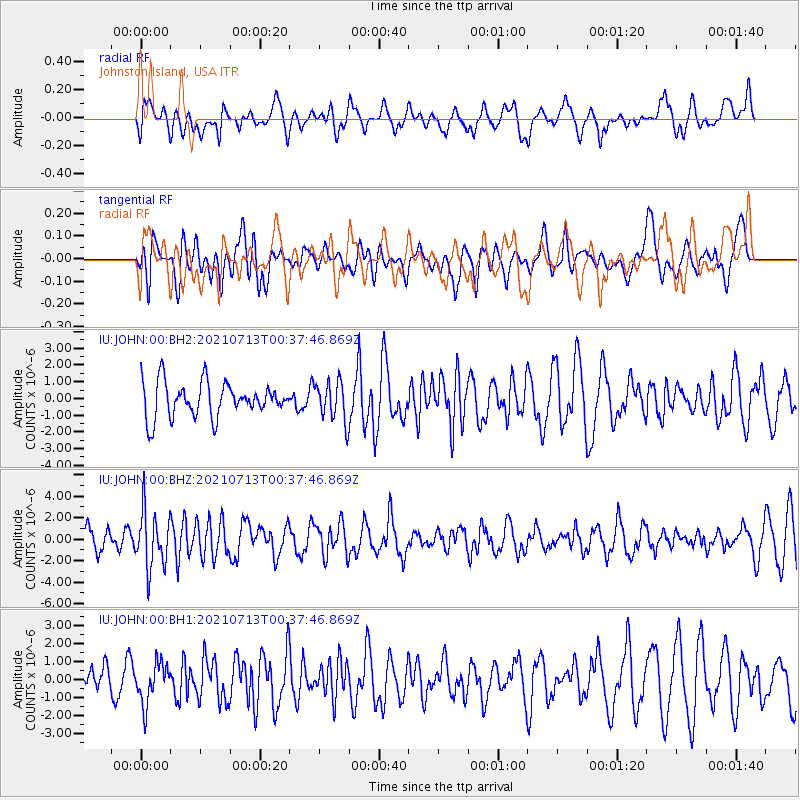
JOHN Johnston Island, USA - Earthquake Result Viewer
*The percent match for this event was below the threshold and hence no stack was calculated.
| Earthquake location: |
Kuril Islands |
| Earthquake latitude/longitude: |
46.2/151.7 |
| Earthquake time(UTC): |
2021/07/13 (194) 00:30:16 GMT |
| Earthquake Depth: |
33 km |
| Earthquake Magnitude: |
5.6 Mww |
| Earthquake Catalog/Contributor: |
NEIC PDE/us |
|
| Network: |
IU Global Seismograph Network (GSN - IRIS/USGS) |
| Station: |
JOHN Johnston Island, USA |
| Lat/Lon: |
16.73 N/169.53 W |
| Elevation: |
2.0 m |
|
| Distance: |
43.6 deg |
| Az: |
119.373 deg |
| Baz: |
320.806 deg |
| Ray Param: |
$rayparam |
*The percent match for this event was below the threshold and hence was not used in the summary stack. |
|
| Radial Match: |
54.09796 % |
| Radial Bump: |
400 |
| Transverse Match: |
54.25523 % |
| Transverse Bump: |
400 |
| SOD ConfigId: |
25131211 |
| Insert Time: |
2021-07-27 00:47:25.999 +0000 |
| GWidth: |
2.5 |
| Max Bumps: |
400 |
| Tol: |
0.001 |
|
Signal To Noise
| Channel | StoN | STA | LTA |
| IU:JOHN:00:BHZ:20210713T00:37:46.869Z | 2.2651434 | 2.6312273E-6 | 1.1616163E-6 |
| IU:JOHN:00:BH1:20210713T00:37:46.869Z | 0.91765153 | 1.1156164E-6 | 1.2157299E-6 |
| IU:JOHN:00:BH2:20210713T00:37:46.869Z | 1.1536196 | 1.1831646E-6 | 1.0256107E-6 |
| Arrivals |
| Ps | |
| PpPs | |
| PsPs/PpSs | |


