You are here: Home > Network List > IU - Global Seismograph Network (GSN - IRIS/USGS) Stations List
> Station POHA Pohakuloa, Hawaii, USA > Earthquake Result Viewer
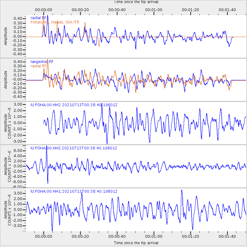
POHA Pohakuloa, Hawaii, USA - Earthquake Result Viewer
*The percent match for this event was below the threshold and hence no stack was calculated.
| Earthquake location: |
Kuril Islands |
| Earthquake latitude/longitude: |
46.2/151.7 |
| Earthquake time(UTC): |
2021/07/13 (194) 00:30:16 GMT |
| Earthquake Depth: |
33 km |
| Earthquake Magnitude: |
5.6 Mww |
| Earthquake Catalog/Contributor: |
NEIC PDE/us |
|
| Network: |
IU Global Seismograph Network (GSN - IRIS/USGS) |
| Station: |
POHA Pohakuloa, Hawaii, USA |
| Lat/Lon: |
19.76 N/155.53 W |
| Elevation: |
1990 m |
|
| Distance: |
50.4 deg |
| Az: |
103.192 deg |
| Baz: |
314.088 deg |
| Ray Param: |
$rayparam |
*The percent match for this event was below the threshold and hence was not used in the summary stack. |
|
| Radial Match: |
56.13179 % |
| Radial Bump: |
400 |
| Transverse Match: |
62.422134 % |
| Transverse Bump: |
400 |
| SOD ConfigId: |
25131211 |
| Insert Time: |
2021-07-27 00:47:33.735 +0000 |
| GWidth: |
2.5 |
| Max Bumps: |
400 |
| Tol: |
0.001 |
|
Signal To Noise
| Channel | StoN | STA | LTA |
| IU:POHA:00:HHZ:20210713T00:38:40.19801Z | 3.0806935 | 2.5372237E-6 | 8.235885E-7 |
| IU:POHA:00:HH1:20210713T00:38:40.19801Z | 1.325059 | 1.1509503E-6 | 8.68603E-7 |
| IU:POHA:00:HH2:20210713T00:38:40.19801Z | 1.4131347 | 1.4510221E-6 | 1.0268109E-6 |
| Arrivals |
| Ps | |
| PpPs | |
| PsPs/PpSs | |


