You are here: Home > Network List > NN - Western Great Basin/Eastern Sierra Nevada Stations List
> Station MCM05 Monte Cristo Menlo 05 > Earthquake Result Viewer
MCM05 Monte Cristo Menlo 05 - Earthquake Result Viewer
| Earthquake location: |
Kuril Islands |
| Earthquake latitude/longitude: |
46.2/151.7 |
| Earthquake time(UTC): |
2021/07/13 (194) 00:30:16 GMT |
| Earthquake Depth: |
33 km |
| Earthquake Magnitude: |
5.6 Mww |
| Earthquake Catalog/Contributor: |
NEIC PDE/us |
|
| Network: |
NN Western Great Basin/Eastern Sierra Nevada |
| Station: |
MCM05 Monte Cristo Menlo 05 |
| Lat/Lon: |
38.16 N/117.87 W |
| Elevation: |
1591 m |
|
| Distance: |
64.0 deg |
| Az: |
61.265 deg |
| Baz: |
309.388 deg |
| Ray Param: |
0.059137486 |
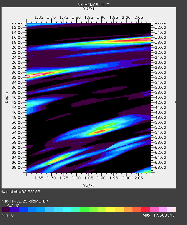
| Estimated Moho Depth: |
31.25 km |
| Estimated Crust Vp/Vs: |
1.61 |
| Assumed Crust Vp: |
6.276 km/s |
| Estimated Crust Vs: |
3.898 km/s |
| Estimated Crust Poisson's Ratio: |
0.19 |
|
| Radial Match: |
83.83188 % |
| Radial Bump: |
400 |
| Transverse Match: |
71.38981 % |
| Transverse Bump: |
400 |
| SOD ConfigId: |
25131211 |
| Insert Time: |
2021-07-27 00:53:25.906 +0000 |
| GWidth: |
2.5 |
| Max Bumps: |
400 |
| Tol: |
0.001 |
|

Signal To Noise
| Channel | StoN | STA | LTA |
| NN:MCM05: :HHZ:20210713T00:40:16.120007Z | 18.292463 | 2.3234854E-6 | 1.2701872E-7 |
| NN:MCM05: :HHN:20210713T00:40:16.120007Z | 6.7235885 | 7.491248E-7 | 1.11417414E-7 |
| NN:MCM05: :HHE:20210713T00:40:16.120007Z | 5.429221 | 8.35375E-7 | 1.5386645E-7 |
| Arrivals |
| Ps | 3.2 SECOND |
| PpPs | 12 SECOND |
| PsPs/PpSs | 16 SECOND |


