You are here: Home > Network List > O2 - Oklahoma Consolidated Temporary Seismic Networks Stations List
> Station DRUM Drumwright, Oklahoma, USA > Earthquake Result Viewer
DRUM Drumwright, Oklahoma, USA - Earthquake Result Viewer
| Earthquake location: |
Kuril Islands |
| Earthquake latitude/longitude: |
46.2/151.7 |
| Earthquake time(UTC): |
2021/07/13 (194) 00:30:16 GMT |
| Earthquake Depth: |
33 km |
| Earthquake Magnitude: |
5.6 Mww |
| Earthquake Catalog/Contributor: |
NEIC PDE/us |
|
| Network: |
O2 Oklahoma Consolidated Temporary Seismic Networks |
| Station: |
DRUM Drumwright, Oklahoma, USA |
| Lat/Lon: |
35.92 N/96.61 W |
| Elevation: |
296 m |
|
| Distance: |
77.8 deg |
| Az: |
50.475 deg |
| Baz: |
318.678 deg |
| Ray Param: |
0.05003283 |
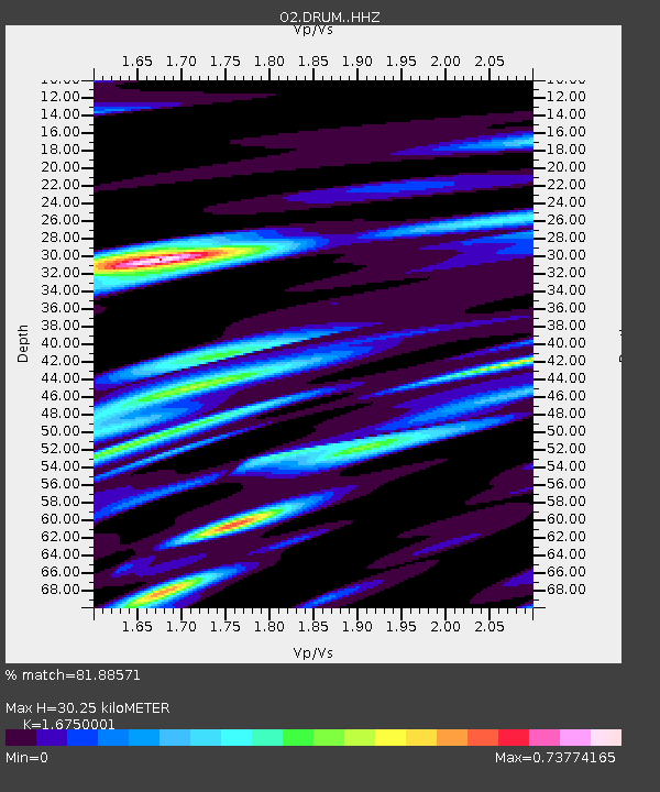
| Estimated Moho Depth: |
30.25 km |
| Estimated Crust Vp/Vs: |
1.68 |
| Assumed Crust Vp: |
6.426 km/s |
| Estimated Crust Vs: |
3.836 km/s |
| Estimated Crust Poisson's Ratio: |
0.22 |
|
| Radial Match: |
81.88571 % |
| Radial Bump: |
335 |
| Transverse Match: |
63.237534 % |
| Transverse Bump: |
400 |
| SOD ConfigId: |
25131211 |
| Insert Time: |
2021-07-27 00:54:28.909 +0000 |
| GWidth: |
2.5 |
| Max Bumps: |
400 |
| Tol: |
0.001 |
|

Signal To Noise
| Channel | StoN | STA | LTA |
| O2:DRUM: :HHZ:20210713T00:41:39.52998Z | 26.186245 | 1.3991652E-6 | 5.3431304E-8 |
| O2:DRUM: :HHN:20210713T00:41:39.52998Z | 7.9752245 | 3.1874075E-7 | 3.9966366E-8 |
| O2:DRUM: :HHE:20210713T00:41:39.52998Z | 5.542482 | 3.9287016E-7 | 7.088344E-8 |
| Arrivals |
| Ps | 3.3 SECOND |
| PpPs | 12 SECOND |
| PsPs/PpSs | 15 SECOND |


