You are here: Home > Network List > US - United States National Seismic Network Stations List
> Station GLMI Grayling, Michigan, USA > Earthquake Result Viewer
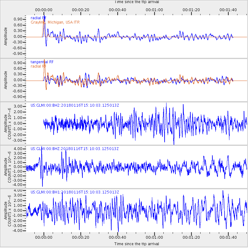
GLMI Grayling, Michigan, USA - Earthquake Result Viewer
*The percent match for this event was below the threshold and hence no stack was calculated.
| Earthquake location: |
Off Coast Of Costa Rica |
| Earthquake latitude/longitude: |
10.9/-86.3 |
| Earthquake time(UTC): |
2018/01/16 (016) 15:03:54 GMT |
| Earthquake Depth: |
31 km |
| Earthquake Magnitude: |
5.9 Mww |
| Earthquake Catalog/Contributor: |
NEIC PDE/us |
|
| Network: |
US United States National Seismic Network |
| Station: |
GLMI Grayling, Michigan, USA |
| Lat/Lon: |
44.82 N/84.62 W |
| Elevation: |
387 m |
|
| Distance: |
33.8 deg |
| Az: |
2.212 deg |
| Baz: |
183.054 deg |
| Ray Param: |
$rayparam |
*The percent match for this event was below the threshold and hence was not used in the summary stack. |
|
| Radial Match: |
68.288635 % |
| Radial Bump: |
400 |
| Transverse Match: |
56.388626 % |
| Transverse Bump: |
400 |
| SOD ConfigId: |
2543731 |
| Insert Time: |
2018-01-30 15:06:16.544 +0000 |
| GWidth: |
2.5 |
| Max Bumps: |
400 |
| Tol: |
0.001 |
|
Signal To Noise
| Channel | StoN | STA | LTA |
| US:GLMI:00:BHZ:20180116T15:10:03.125013Z | 3.2867317 | 1.2434236E-6 | 3.7831614E-7 |
| US:GLMI:00:BH1:20180116T15:10:03.125013Z | 1.5130534 | 1.045586E-6 | 6.910437E-7 |
| US:GLMI:00:BH2:20180116T15:10:03.125013Z | 1.1546912 | 7.1706745E-7 | 6.210036E-7 |
| Arrivals |
| Ps | |
| PpPs | |
| PsPs/PpSs | |


