You are here: Home > Network List > OH - Ohio Seismic Network Stations List
> Station SLSO Stonelick State Park Ohio > Earthquake Result Viewer
SLSO Stonelick State Park Ohio - Earthquake Result Viewer
| Earthquake location: |
Kuril Islands |
| Earthquake latitude/longitude: |
46.2/151.7 |
| Earthquake time(UTC): |
2021/07/13 (194) 00:30:16 GMT |
| Earthquake Depth: |
33 km |
| Earthquake Magnitude: |
5.6 Mww |
| Earthquake Catalog/Contributor: |
NEIC PDE/us |
|
| Network: |
OH Ohio Seismic Network |
| Station: |
SLSO Stonelick State Park Ohio |
| Lat/Lon: |
39.22 N/84.06 W |
| Elevation: |
272 m |
|
| Distance: |
81.4 deg |
| Az: |
40.465 deg |
| Baz: |
324.512 deg |
| Ray Param: |
0.047545746 |
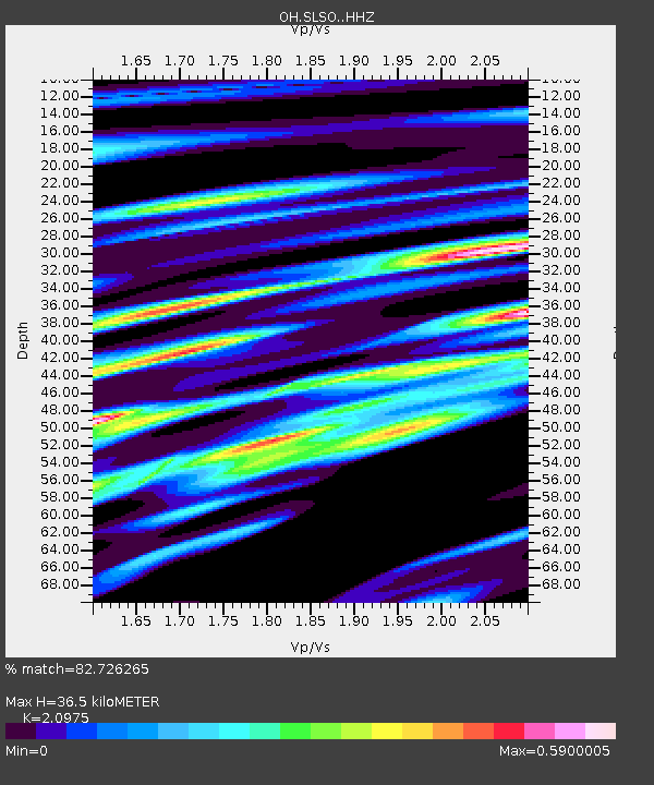
| Estimated Moho Depth: |
36.5 km |
| Estimated Crust Vp/Vs: |
2.10 |
| Assumed Crust Vp: |
6.498 km/s |
| Estimated Crust Vs: |
3.098 km/s |
| Estimated Crust Poisson's Ratio: |
0.35 |
|
| Radial Match: |
82.726265 % |
| Radial Bump: |
322 |
| Transverse Match: |
61.778786 % |
| Transverse Bump: |
392 |
| SOD ConfigId: |
25131211 |
| Insert Time: |
2021-07-27 00:56:00.996 +0000 |
| GWidth: |
2.5 |
| Max Bumps: |
400 |
| Tol: |
0.001 |
|

Signal To Noise
| Channel | StoN | STA | LTA |
| OH:SLSO: :HHZ:20210713T00:41:59.159985Z | 6.5203557 | 9.557876E-7 | 1.4658521E-7 |
| OH:SLSO: :HHN:20210713T00:41:59.159985Z | 5.1949325 | 2.9463402E-7 | 5.671566E-8 |
| OH:SLSO: :HHE:20210713T00:41:59.159985Z | 2.2608147 | 2.6016912E-7 | 1.150776E-7 |
| Arrivals |
| Ps | 6.3 SECOND |
| PpPs | 17 SECOND |
| PsPs/PpSs | 23 SECOND |


