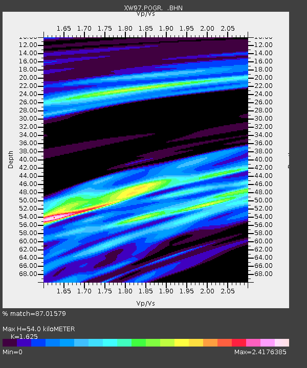
POGR XW.POGR - Earthquake Result Viewer
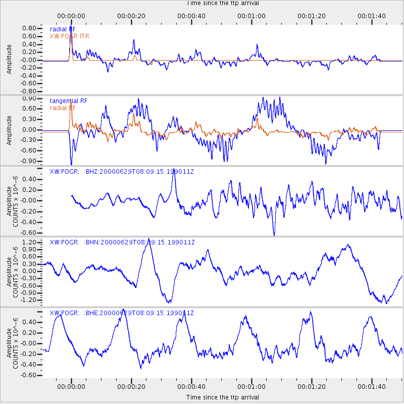
Earthquake location: Mariana Islands
Earthquake latitude/longitude: 13.0/144.5
Earthquake time(UTC): 2000/06/29 (181) 07:59:06 GMT
Earthquake Depth: 52 km
Earthquake Magnitude: 5.5 MB, 5.5 MS, 5.9 MW, 5.8 MW
Earthquake Catalog/Contributor: WHDF/NEIC
Network: XW Tien Shan Continental Dynamics
Station: POGR XW.POGR
Lat/Lon: 41.02 N/75.55 E
Elevation: 2357 m
Distance: 65.7 deg
Az: 309.214 deg
Baz: 93.707 deg
Ray Param: 0.057961885
Estimated Moho Depth: 54.0 km
Estimated Crust Vp/Vs: 1.62
Assumed Crust Vp: 6.491 km/s
Estimated Crust Vs: 3.994 km/s
Estimated Crust Poisson's Ratio: 0.20
Radial Match: 87.01579 %
Radial Bump: 302
Transverse Match: 71.97815 %
Transverse Bump: 400
SOD ConfigId: 20082
Insert Time: 2010-02-26 15:45:07.842 +0000
GWidth: 2.5
Max Bumps: 400
Tol: 0.001

Signal To Noise

ChannelStoNSTALTA
XW:POGR: :BHN:20000629T08:09:15.199011Z0.81566042.4485183E-73.0018845E-7
XW:POGR: :BHE:20000629T08:09:15.199011Z0.936712862.1037205E-72.2458542E-7
XW:POGR: :BHZ:20000629T08:09:15.199011Z3.31936052.429848E-77.3202294E-8
Arrivals
Ps5.4 SECOND
PpPs21 SECOND
PsPs/PpSs26 SECOND