You are here: Home > Network List > TX - Texas Seismological Network Stations List
> Station BRDY Brady > Earthquake Result Viewer
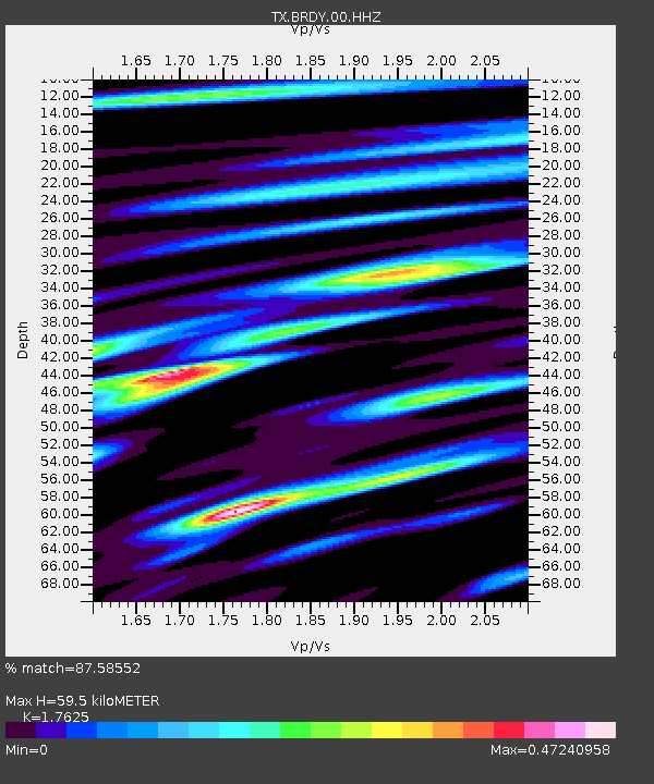
BRDY Brady - Earthquake Result Viewer
| Earthquake location: |
Kuril Islands |
| Earthquake latitude/longitude: |
46.2/151.7 |
| Earthquake time(UTC): |
2021/07/13 (194) 00:30:16 GMT |
| Earthquake Depth: |
33 km |
| Earthquake Magnitude: |
5.6 Mww |
| Earthquake Catalog/Contributor: |
NEIC PDE/us |
|
| Network: |
TX Texas Seismological Network |
| Station: |
BRDY Brady |
| Lat/Lon: |
31.27 N/99.00 W |
| Elevation: |
460 m |
|
| Distance: |
80.0 deg |
| Az: |
55.136 deg |
| Baz: |
318.254 deg |
| Ray Param: |
0.04856865 |
| Estimated Moho Depth: |
59.5 km |
| Estimated Crust Vp/Vs: |
1.76 |
| Assumed Crust Vp: |
6.498 km/s |
| Estimated Crust Vs: |
3.687 km/s |
| Estimated Crust Poisson's Ratio: |
0.26 |
|
| Radial Match: |
87.58552 % |
| Radial Bump: |
400 |
| Transverse Match: |
72.441734 % |
| Transverse Bump: |
400 |
| SOD ConfigId: |
25131211 |
| Insert Time: |
2021-07-27 01:00:18.694 +0000 |
| GWidth: |
2.5 |
| Max Bumps: |
400 |
| Tol: |
0.001 |
|

Signal To Noise
| Channel | StoN | STA | LTA |
| TX:BRDY:00:HHZ:20210713T00:41:51.190014Z | 13.869503 | 8.810458E-7 | 6.352396E-8 |
| TX:BRDY:00:HH1:20210713T00:41:51.190014Z | 3.3652744 | 1.6086152E-7 | 4.780042E-8 |
| TX:BRDY:00:HH2:20210713T00:41:51.190014Z | 8.362108 | 2.718329E-7 | 3.25077E-8 |
| Arrivals |
| Ps | 7.2 SECOND |
| PpPs | 25 SECOND |
| PsPs/PpSs | 32 SECOND |


