You are here: Home > Network List > TX - Texas Seismological Network Stations List
> Station SAND Sanderson > Earthquake Result Viewer
SAND Sanderson - Earthquake Result Viewer
| Earthquake location: |
Kuril Islands |
| Earthquake latitude/longitude: |
46.2/151.7 |
| Earthquake time(UTC): |
2021/07/13 (194) 00:30:16 GMT |
| Earthquake Depth: |
33 km |
| Earthquake Magnitude: |
5.6 Mww |
| Earthquake Catalog/Contributor: |
NEIC PDE/us |
|
| Network: |
TX Texas Seismological Network |
| Station: |
SAND Sanderson |
| Lat/Lon: |
29.95 N/102.12 W |
| Elevation: |
689 m |
|
| Distance: |
79.1 deg |
| Az: |
58.056 deg |
| Baz: |
317.204 deg |
| Ray Param: |
0.04914056 |
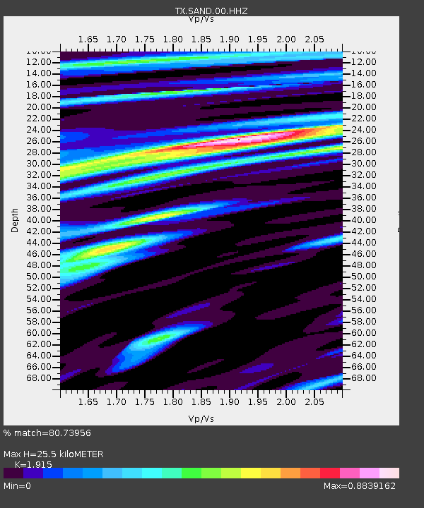
| Estimated Moho Depth: |
25.5 km |
| Estimated Crust Vp/Vs: |
1.91 |
| Assumed Crust Vp: |
6.419 km/s |
| Estimated Crust Vs: |
3.352 km/s |
| Estimated Crust Poisson's Ratio: |
0.31 |
|
| Radial Match: |
80.73956 % |
| Radial Bump: |
400 |
| Transverse Match: |
55.26903 % |
| Transverse Bump: |
374 |
| SOD ConfigId: |
25131211 |
| Insert Time: |
2021-07-27 01:01:29.979 +0000 |
| GWidth: |
2.5 |
| Max Bumps: |
400 |
| Tol: |
0.001 |
|

Signal To Noise
| Channel | StoN | STA | LTA |
| TX:SAND:00:HHZ:20210713T00:41:46.695019Z | 7.0096297 | 9.488336E-7 | 1.3536145E-7 |
| TX:SAND:00:HH1:20210713T00:41:46.695019Z | 2.0919979 | 1.2407202E-7 | 5.930791E-8 |
| TX:SAND:00:HH2:20210713T00:41:46.695019Z | 4.660343 | 3.6553382E-7 | 7.843496E-8 |
| Arrivals |
| Ps | 3.7 SECOND |
| PpPs | 11 SECOND |
| PsPs/PpSs | 15 SECOND |


