You are here: Home > Network List > XW97 - Tien Shan Continental Dynamics Stations List
> Station POGR XW.POGR > Earthquake Result Viewer
POGR XW.POGR - Earthquake Result Viewer
| Earthquake location: |
Mariana Islands |
| Earthquake latitude/longitude: |
14.1/145.0 |
| Earthquake time(UTC): |
2000/06/21 (173) 16:25:06 GMT |
| Earthquake Depth: |
112 km |
| Earthquake Magnitude: |
5.7 MB, 6.0 MW, 5.9 MW |
| Earthquake Catalog/Contributor: |
WHDF/NEIC |
|
| Network: |
XW Tien Shan Continental Dynamics |
| Station: |
POGR XW.POGR |
| Lat/Lon: |
41.02 N/75.55 E |
| Elevation: |
2357 m |
|
| Distance: |
65.4 deg |
| Az: |
308.815 deg |
| Baz: |
92.504 deg |
| Ray Param: |
0.05800366 |
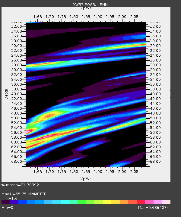
| Estimated Moho Depth: |
55.75 km |
| Estimated Crust Vp/Vs: |
1.60 |
| Assumed Crust Vp: |
6.491 km/s |
| Estimated Crust Vs: |
4.057 km/s |
| Estimated Crust Poisson's Ratio: |
0.18 |
|
| Radial Match: |
91.70092 % |
| Radial Bump: |
362 |
| Transverse Match: |
61.91018 % |
| Transverse Bump: |
400 |
| SOD ConfigId: |
20082 |
| Insert Time: |
2010-02-26 15:45:10.811 +0000 |
| GWidth: |
2.5 |
| Max Bumps: |
400 |
| Tol: |
0.001 |
|
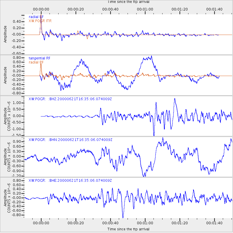
Signal To Noise
| Channel | StoN | STA | LTA |
| XW:POGR: :BHN:20000621T16:35:06.074009Z | 0.4920044 | 2.3169812E-7 | 4.7092692E-7 |
| XW:POGR: :BHE:20000621T16:35:06.074009Z | 3.3273542 | 8.42008E-8 | 2.5305631E-8 |
| XW:POGR: :BHZ:20000621T16:35:06.074009Z | 5.773235 | 1.9853302E-7 | 3.438852E-8 |
| Arrivals |
| Ps | 5.4 SECOND |
| PpPs | 21 SECOND |
| PsPs/PpSs | 27 SECOND |


