You are here: Home > Network List > US - United States National Seismic Network Stations List
> Station AMTX Amarillo, Texas, USA > Earthquake Result Viewer
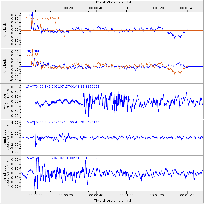
AMTX Amarillo, Texas, USA - Earthquake Result Viewer
*The percent match for this event was below the threshold and hence no stack was calculated.
| Earthquake location: |
Kuril Islands |
| Earthquake latitude/longitude: |
46.2/151.7 |
| Earthquake time(UTC): |
2021/07/13 (194) 00:30:16 GMT |
| Earthquake Depth: |
33 km |
| Earthquake Magnitude: |
5.6 Mww |
| Earthquake Catalog/Contributor: |
NEIC PDE/us |
|
| Network: |
US United States National Seismic Network |
| Station: |
AMTX Amarillo, Texas, USA |
| Lat/Lon: |
34.53 N/101.41 W |
| Elevation: |
1010 m |
|
| Distance: |
76.2 deg |
| Az: |
54.418 deg |
| Baz: |
316.806 deg |
| Ray Param: |
$rayparam |
*The percent match for this event was below the threshold and hence was not used in the summary stack. |
|
| Radial Match: |
70.53782 % |
| Radial Bump: |
400 |
| Transverse Match: |
72.59039 % |
| Transverse Bump: |
400 |
| SOD ConfigId: |
25131211 |
| Insert Time: |
2021-07-27 01:02:59.817 +0000 |
| GWidth: |
2.5 |
| Max Bumps: |
400 |
| Tol: |
0.001 |
|
Signal To Noise
| Channel | StoN | STA | LTA |
| US:AMTX:00:BHZ:20210713T00:41:28.125012Z | 11.033237 | 1.5493147E-6 | 1.4042249E-7 |
| US:AMTX:00:BH1:20210713T00:41:28.125012Z | 4.127799 | 5.617862E-7 | 1.3609824E-7 |
| US:AMTX:00:BH2:20210713T00:41:28.125012Z | 4.113452 | 4.5465106E-7 | 1.10527864E-7 |
| Arrivals |
| Ps | |
| PpPs | |
| PsPs/PpSs | |


