You are here: Home > Network List > US - United States National Seismic Network Stations List
> Station TPNV Topopah Spring, Nevada, USA > Earthquake Result Viewer
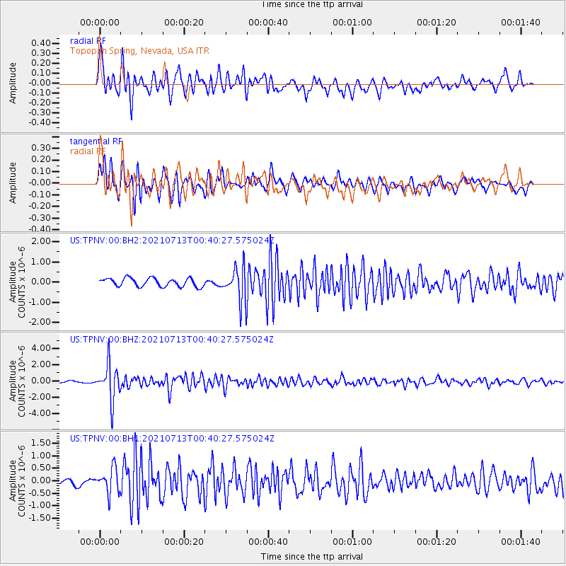
TPNV Topopah Spring, Nevada, USA - Earthquake Result Viewer
*The percent match for this event was below the threshold and hence no stack was calculated.
| Earthquake location: |
Kuril Islands |
| Earthquake latitude/longitude: |
46.2/151.7 |
| Earthquake time(UTC): |
2021/07/13 (194) 00:30:16 GMT |
| Earthquake Depth: |
33 km |
| Earthquake Magnitude: |
5.6 Mww |
| Earthquake Catalog/Contributor: |
NEIC PDE/us |
|
| Network: |
US United States National Seismic Network |
| Station: |
TPNV Topopah Spring, Nevada, USA |
| Lat/Lon: |
36.95 N/116.25 W |
| Elevation: |
1600 m |
|
| Distance: |
65.8 deg |
| Az: |
61.373 deg |
| Baz: |
310.419 deg |
| Ray Param: |
$rayparam |
*The percent match for this event was below the threshold and hence was not used in the summary stack. |
|
| Radial Match: |
83.466034 % |
| Radial Bump: |
400 |
| Transverse Match: |
73.08009 % |
| Transverse Bump: |
400 |
| SOD ConfigId: |
25131211 |
| Insert Time: |
2021-07-27 01:04:01.072 +0000 |
| GWidth: |
2.5 |
| Max Bumps: |
400 |
| Tol: |
0.001 |
|
Signal To Noise
| Channel | StoN | STA | LTA |
| US:TPNV:00:BHZ:20210713T00:40:27.575024Z | 16.100554 | 2.2878319E-6 | 1.4209647E-7 |
| US:TPNV:00:BH1:20210713T00:40:27.575024Z | 3.9885547 | 5.2001946E-7 | 1.3037791E-7 |
| US:TPNV:00:BH2:20210713T00:40:27.575024Z | 4.183671 | 8.586205E-7 | 2.0523137E-7 |
| Arrivals |
| Ps | |
| PpPs | |
| PsPs/PpSs | |


