You are here: Home > Network List > XW97 - Tien Shan Continental Dynamics Stations List
> Station POGR XW.POGR > Earthquake Result Viewer
POGR XW.POGR - Earthquake Result Viewer
| Earthquake location: |
Southeast Of Honshu, Japan |
| Earthquake latitude/longitude: |
30.5/137.7 |
| Earthquake time(UTC): |
2000/06/09 (161) 23:31:45 GMT |
| Earthquake Depth: |
485 km |
| Earthquake Magnitude: |
5.9 MB, 6.3 MW, 6.2 MW |
| Earthquake Catalog/Contributor: |
WHDF/NEIC |
|
| Network: |
XW Tien Shan Continental Dynamics |
| Station: |
POGR XW.POGR |
| Lat/Lon: |
41.02 N/75.55 E |
| Elevation: |
2357 m |
|
| Distance: |
50.6 deg |
| Az: |
299.979 deg |
| Baz: |
81.166 deg |
| Ray Param: |
0.065848306 |
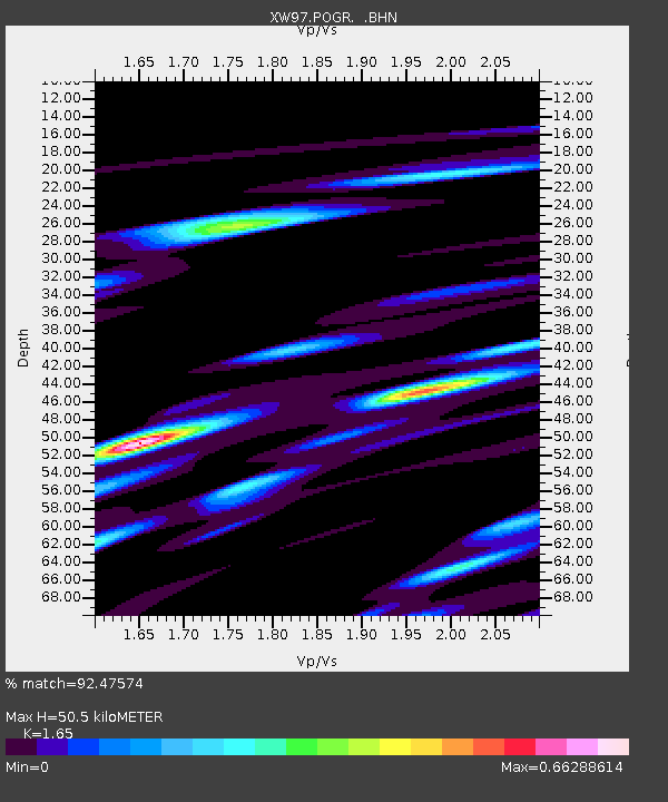
| Estimated Moho Depth: |
50.5 km |
| Estimated Crust Vp/Vs: |
1.65 |
| Assumed Crust Vp: |
6.491 km/s |
| Estimated Crust Vs: |
3.934 km/s |
| Estimated Crust Poisson's Ratio: |
0.21 |
|
| Radial Match: |
92.47574 % |
| Radial Bump: |
400 |
| Transverse Match: |
54.79895 % |
| Transverse Bump: |
400 |
| SOD ConfigId: |
20082 |
| Insert Time: |
2010-02-26 15:45:18.344 +0000 |
| GWidth: |
2.5 |
| Max Bumps: |
400 |
| Tol: |
0.001 |
|
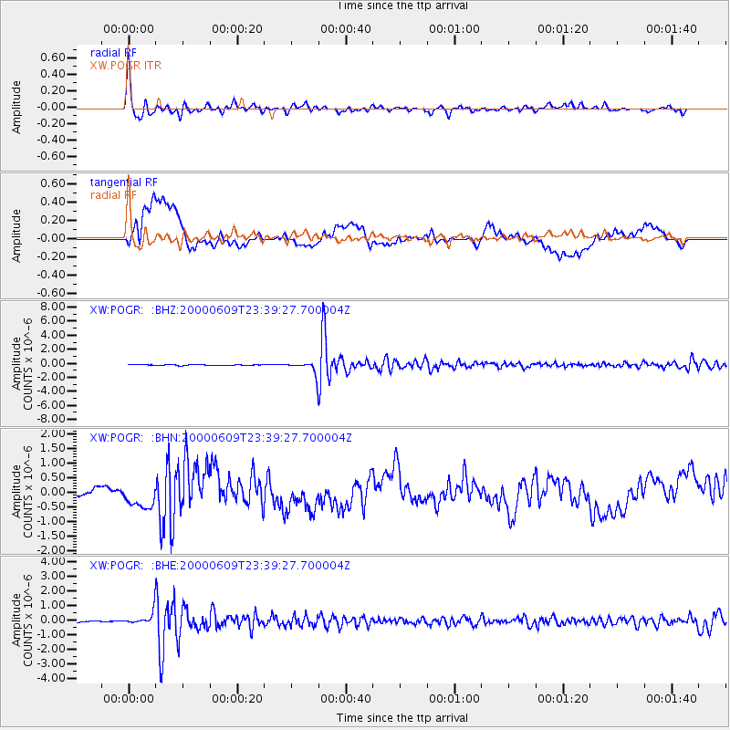
Signal To Noise
| Channel | StoN | STA | LTA |
| XW:POGR: :BHN:20000609T23:39:27.700004Z | 1.6046118 | 3.2175973E-7 | 2.0052185E-7 |
| XW:POGR: :BHE:20000609T23:39:27.700004Z | 13.18519 | 4.5678374E-7 | 3.4643698E-8 |
| XW:POGR: :BHZ:20000609T23:39:27.700004Z | 17.237398 | 9.555671E-7 | 5.5435695E-8 |
| Arrivals |
| Ps | 5.4 SECOND |
| PpPs | 19 SECOND |
| PsPs/PpSs | 25 SECOND |


