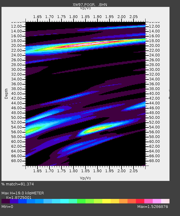
POGR XW.POGR - Earthquake Result Viewer
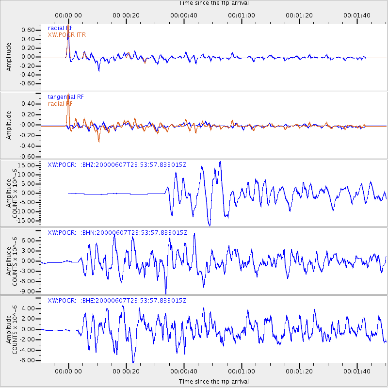
Earthquake location: Southern Sumatra, Indonesia
Earthquake latitude/longitude: -4.6/101.9
Earthquake time(UTC): 2000/06/07 (159) 23:45:26 GMT
Earthquake Depth: 33 km
Earthquake Magnitude: 6.1 MB, 6.7 MS, 6.7 MW, 6.5 MW
Earthquake Catalog/Contributor: WHDF/NEIC
Network: XW Tien Shan Continental Dynamics
Station: POGR XW.POGR
Lat/Lon: 41.02 N/75.55 E
Elevation: 2357 m
Distance: 51.4 deg
Az: 334.551 deg
Baz: 145.523 deg
Ray Param: 0.06736665
Estimated Moho Depth: 19.0 km
Estimated Crust Vp/Vs: 1.87
Assumed Crust Vp: 6.491 km/s
Estimated Crust Vs: 3.466 km/s
Estimated Crust Poisson's Ratio: 0.30
Radial Match: 91.374 %
Radial Bump: 400
Transverse Match: 85.33558 %
Transverse Bump: 400
SOD ConfigId: 20082
Insert Time: 2010-02-26 15:45:21.683 +0000
GWidth: 2.5
Max Bumps: 400
Tol: 0.001

Signal To Noise

ChannelStoNSTALTA
XW:POGR: :BHN:20000607T23:53:57.833015Z1.8392033.804242E-72.0684188E-7
XW:POGR: :BHE:20000607T23:53:57.833015Z6.25445373.6989857E-75.9141623E-8
XW:POGR: :BHZ:20000607T23:53:57.833015Z7.47685341.1950498E-61.5983325E-7
Arrivals
Ps2.7 SECOND
PpPs8.0 SECOND
PsPs/PpSs11 SECOND