You are here: Home > Network List > US - United States National Seismic Network Stations List
> Station ELK Elko, Nevada, USA > Earthquake Result Viewer
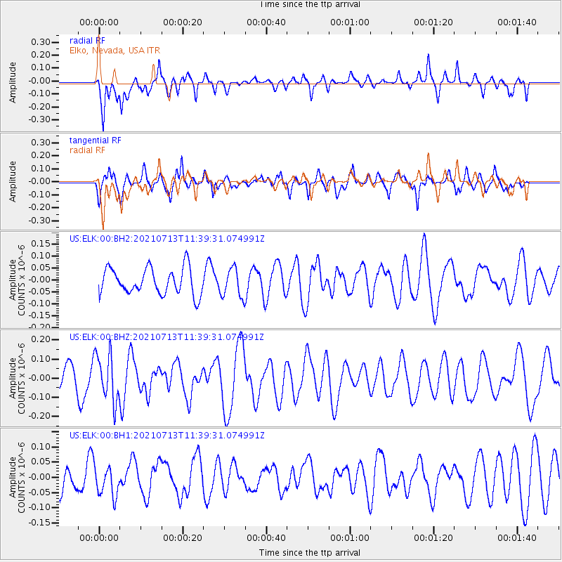
ELK Elko, Nevada, USA - Earthquake Result Viewer
*The percent match for this event was below the threshold and hence no stack was calculated.
| Earthquake location: |
Southeast Of Loyalty Islands |
| Earthquake latitude/longitude: |
-23.3/172.3 |
| Earthquake time(UTC): |
2021/07/13 (194) 11:26:50 GMT |
| Earthquake Depth: |
10 km |
| Earthquake Magnitude: |
5.4 Mww |
| Earthquake Catalog/Contributor: |
NEIC PDE/us |
|
| Network: |
US United States National Seismic Network |
| Station: |
ELK Elko, Nevada, USA |
| Lat/Lon: |
40.74 N/115.24 W |
| Elevation: |
2210 m |
|
| Distance: |
92.6 deg |
| Az: |
46.501 deg |
| Baz: |
241.368 deg |
| Ray Param: |
$rayparam |
*The percent match for this event was below the threshold and hence was not used in the summary stack. |
|
| Radial Match: |
69.73695 % |
| Radial Bump: |
400 |
| Transverse Match: |
73.168526 % |
| Transverse Bump: |
400 |
| SOD ConfigId: |
25131211 |
| Insert Time: |
2021-07-27 11:39:02.317 +0000 |
| GWidth: |
2.5 |
| Max Bumps: |
400 |
| Tol: |
0.001 |
|
Signal To Noise
| Channel | StoN | STA | LTA |
| US:ELK:00:BHZ:20210713T11:39:31.074991Z | 2.2586265 | 1.2205815E-7 | 5.404088E-8 |
| US:ELK:00:BH1:20210713T11:39:31.074991Z | 0.8606362 | 4.701515E-8 | 5.462837E-8 |
| US:ELK:00:BH2:20210713T11:39:31.074991Z | 1.1090554 | 6.129168E-8 | 5.5264756E-8 |
| Arrivals |
| Ps | |
| PpPs | |
| PsPs/PpSs | |


