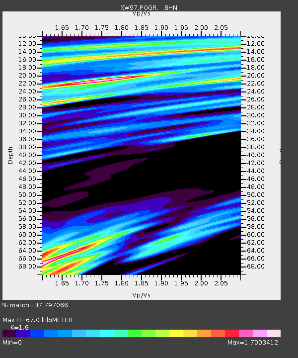
POGR XW.POGR - Earthquake Result Viewer
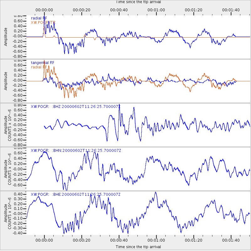
Earthquake location: Off Coast Of Oregon
Earthquake latitude/longitude: 44.5/-130.1
Earthquake time(UTC): 2000/06/02 (154) 11:13:49 GMT
Earthquake Depth: 10 km
Earthquake Magnitude: 5.8 MB, 6.0 MS, 6.2 MW, 6.2 MW
Earthquake Catalog/Contributor: WHDF/NEIC
Network: XW Tien Shan Continental Dynamics
Station: POGR XW.POGR
Lat/Lon: 41.02 N/75.55 E
Elevation: 2357 m
Distance: 91.8 deg
Az: 340.884 deg
Baz: 18.037 deg
Ray Param: 0.04155581
Estimated Moho Depth: 67.0 km
Estimated Crust Vp/Vs: 1.60
Assumed Crust Vp: 6.491 km/s
Estimated Crust Vs: 4.057 km/s
Estimated Crust Poisson's Ratio: 0.18
Radial Match: 87.797066 %
Radial Bump: 400
Transverse Match: 77.257935 %
Transverse Bump: 400
SOD ConfigId: 20082
Insert Time: 2010-02-26 15:45:29.914 +0000
GWidth: 2.5
Max Bumps: 400
Tol: 0.001

Signal To Noise

ChannelStoNSTALTA
XW:POGR: :BHN:20000602T11:26:25.700007Z3.19627716.212683E-71.9437248E-7
XW:POGR: :BHE:20000602T11:26:25.700007Z1.18468422.2782896E-71.9231197E-7
XW:POGR: :BHZ:20000602T11:26:25.700007Z2.77885222.4876127E-78.951944E-8
Arrivals
Ps6.3 SECOND
PpPs26 SECOND
PsPs/PpSs33 SECOND