You are here: Home > Network List > IU - Global Seismograph Network (GSN - IRIS/USGS) Stations List
> Station CTAO Charters Towers, Australia > Earthquake Result Viewer
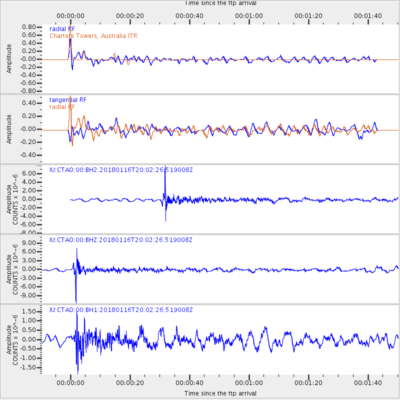
CTAO Charters Towers, Australia - Earthquake Result Viewer
*The percent match for this event was below the threshold and hence no stack was calculated.
| Earthquake location: |
Fiji Islands Region |
| Earthquake latitude/longitude: |
-19.5/-179.3 |
| Earthquake time(UTC): |
2018/01/16 (016) 19:57:18 GMT |
| Earthquake Depth: |
666 km |
| Earthquake Magnitude: |
5.9 Mww |
| Earthquake Catalog/Contributor: |
NEIC PDE/us |
|
| Network: |
IU Global Seismograph Network (GSN - IRIS/USGS) |
| Station: |
CTAO Charters Towers, Australia |
| Lat/Lon: |
20.09 S/146.25 E |
| Elevation: |
357 m |
|
| Distance: |
32.4 deg |
| Az: |
262.963 deg |
| Baz: |
94.872 deg |
| Ray Param: |
$rayparam |
*The percent match for this event was below the threshold and hence was not used in the summary stack. |
|
| Radial Match: |
49.213036 % |
| Radial Bump: |
400 |
| Transverse Match: |
52.258556 % |
| Transverse Bump: |
400 |
| SOD ConfigId: |
2546091 |
| Insert Time: |
2018-01-30 19:58:52.233 +0000 |
| GWidth: |
2.5 |
| Max Bumps: |
400 |
| Tol: |
0.001 |
|
Signal To Noise
| Channel | StoN | STA | LTA |
| IU:CTAO:00:BHZ:20180116T20:02:26.519008Z | 9.895668 | 2.30587E-6 | 2.3301813E-7 |
| IU:CTAO:00:BH1:20180116T20:02:26.519008Z | 2.9503813 | 5.4547615E-7 | 1.8488328E-7 |
| IU:CTAO:00:BH2:20180116T20:02:26.519008Z | 7.2873197 | 1.5833963E-6 | 2.1728103E-7 |
| Arrivals |
| Ps | |
| PpPs | |
| PsPs/PpSs | |


