You are here: Home > Network List > AV - Alaska Volcano Observatory Stations List
> Station SPCR Ckakachatna River, Mount Spurr, Alaska > Earthquake Result Viewer
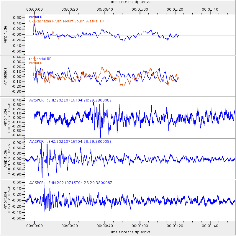
SPCR Ckakachatna River, Mount Spurr, Alaska - Earthquake Result Viewer
*The percent match for this event was below the threshold and hence no stack was calculated.
| Earthquake location: |
Southeast Of Honshu, Japan |
| Earthquake latitude/longitude: |
33.3/139.5 |
| Earthquake time(UTC): |
2021/07/16 (197) 04:19:58 GMT |
| Earthquake Depth: |
11 km |
| Earthquake Magnitude: |
5.5 Mww |
| Earthquake Catalog/Contributor: |
NEIC PDE/us |
|
| Network: |
AV Alaska Volcano Observatory |
| Station: |
SPCR Ckakachatna River, Mount Spurr, Alaska |
| Lat/Lon: |
61.20 N/152.21 W |
| Elevation: |
984 m |
|
| Distance: |
51.1 deg |
| Az: |
35.326 deg |
| Baz: |
269.534 deg |
| Ray Param: |
$rayparam |
*The percent match for this event was below the threshold and hence was not used in the summary stack. |
|
| Radial Match: |
57.518448 % |
| Radial Bump: |
400 |
| Transverse Match: |
70.973145 % |
| Transverse Bump: |
400 |
| SOD ConfigId: |
25131211 |
| Insert Time: |
2021-07-30 04:25:59.782 +0000 |
| GWidth: |
2.5 |
| Max Bumps: |
400 |
| Tol: |
0.001 |
|
Signal To Noise
| Channel | StoN | STA | LTA |
| AV:SPCR: :BHZ:20210716T04:28:29.380008Z | 7.6458306 | 4.042281E-7 | 5.286909E-8 |
| AV:SPCR: :BHN:20210716T04:28:29.380008Z | 0.77867544 | 6.71698E-8 | 8.6261615E-8 |
| AV:SPCR: :BHE:20210716T04:28:29.380008Z | 1.9512138 | 1.5679981E-7 | 8.036014E-8 |
| Arrivals |
| Ps | |
| PpPs | |
| PsPs/PpSs | |


