You are here: Home > Network List > US - United States National Seismic Network Stations List
> Station AMTX Amarillo, Texas, USA > Earthquake Result Viewer
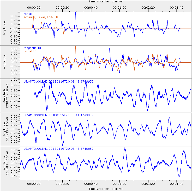
AMTX Amarillo, Texas, USA - Earthquake Result Viewer
*The percent match for this event was below the threshold and hence no stack was calculated.
| Earthquake location: |
Fiji Islands Region |
| Earthquake latitude/longitude: |
-19.5/-179.3 |
| Earthquake time(UTC): |
2018/01/16 (016) 19:57:18 GMT |
| Earthquake Depth: |
666 km |
| Earthquake Magnitude: |
5.9 Mww |
| Earthquake Catalog/Contributor: |
NEIC PDE/us |
|
| Network: |
US United States National Seismic Network |
| Station: |
AMTX Amarillo, Texas, USA |
| Lat/Lon: |
34.53 N/101.41 W |
| Elevation: |
1010 m |
|
| Distance: |
91.3 deg |
| Az: |
53.841 deg |
| Baz: |
247.338 deg |
| Ray Param: |
$rayparam |
*The percent match for this event was below the threshold and hence was not used in the summary stack. |
|
| Radial Match: |
45.988136 % |
| Radial Bump: |
400 |
| Transverse Match: |
64.68132 % |
| Transverse Bump: |
400 |
| SOD ConfigId: |
2546091 |
| Insert Time: |
2018-01-30 19:59:48.067 +0000 |
| GWidth: |
2.5 |
| Max Bumps: |
400 |
| Tol: |
0.001 |
|
Signal To Noise
| Channel | StoN | STA | LTA |
| US:AMTX:00:BHZ:20180116T20:08:43.374995Z | 1.5662258 | 2.6166182E-7 | 1.670652E-7 |
| US:AMTX:00:BH1:20180116T20:08:43.374995Z | 1.7395672 | 2.2093424E-7 | 1.270053E-7 |
| US:AMTX:00:BH2:20180116T20:08:43.374995Z | 0.94132936 | 2.2251201E-7 | 2.3638061E-7 |
| Arrivals |
| Ps | |
| PpPs | |
| PsPs/PpSs | |


