You are here: Home > Network List > US - United States National Seismic Network Stations List
> Station MSO Missoula, Montana, USA > Earthquake Result Viewer
MSO Missoula, Montana, USA - Earthquake Result Viewer
*The percent match for this event was below the threshold and hence no stack was calculated.
| Earthquake location: |
Fiji Islands Region |
| Earthquake latitude/longitude: |
-19.5/-179.3 |
| Earthquake time(UTC): |
2018/01/16 (016) 19:57:18 GMT |
| Earthquake Depth: |
666 km |
| Earthquake Magnitude: |
5.9 Mww |
| Earthquake Catalog/Contributor: |
NEIC PDE/us |
|
| Network: |
US United States National Seismic Network |
| Station: |
MSO Missoula, Montana, USA |
| Lat/Lon: |
46.83 N/113.94 W |
| Elevation: |
1264 m |
|
| Distance: |
88.3 deg |
| Az: |
38.628 deg |
| Baz: |
239.084 deg |
| Ray Param: |
$rayparam |
*The percent match for this event was below the threshold and hence was not used in the summary stack. |
|
| Radial Match: |
66.26294 % |
| Radial Bump: |
400 |
| Transverse Match: |
78.74179 % |
| Transverse Bump: |
352 |
| SOD ConfigId: |
2546091 |
| Insert Time: |
2018-01-30 19:59:58.227 +0000 |
| GWidth: |
2.5 |
| Max Bumps: |
400 |
| Tol: |
0.001 |
|
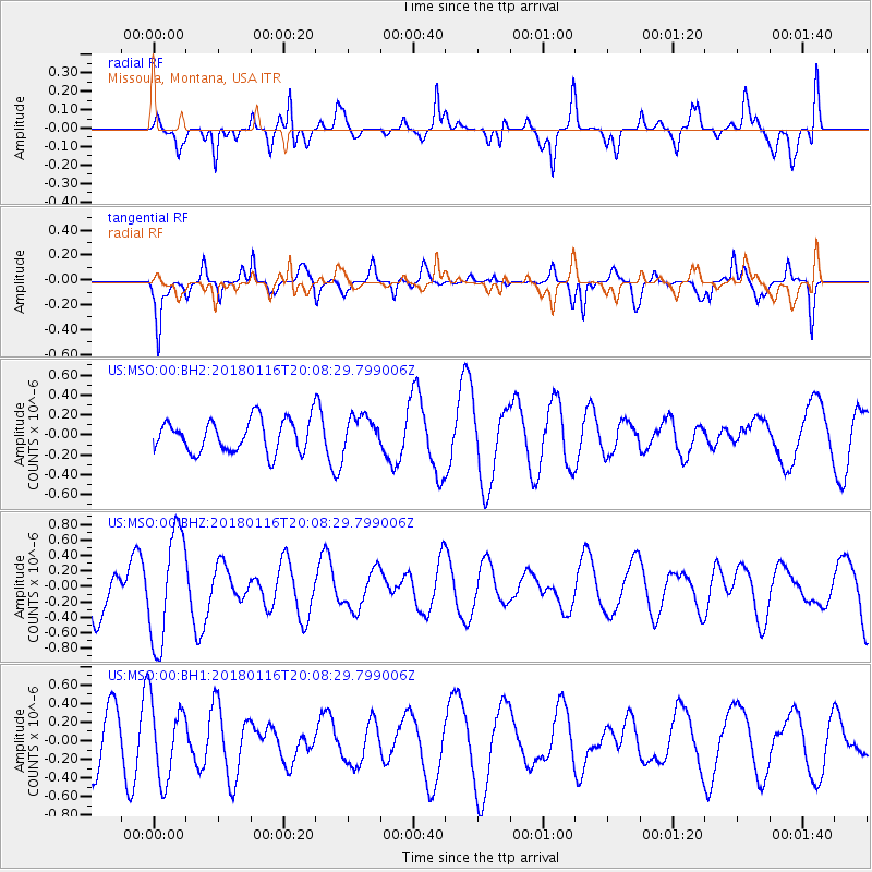
Signal To Noise
| Channel | StoN | STA | LTA |
| US:MSO:00:BHZ:20180116T20:08:29.799006Z | 1.8329012 | 7.1397096E-7 | 3.895305E-7 |
| US:MSO:00:BH1:20180116T20:08:29.799006Z | 1.7081695 | 4.1246471E-7 | 2.4146593E-7 |
| US:MSO:00:BH2:20180116T20:08:29.799006Z | 1.0548782 | 1.7209376E-7 | 1.631409E-7 |
| Arrivals |
| Ps | |
| PpPs | |
| PsPs/PpSs | |


