You are here: Home > Network List > CN - Canadian National Seismograph Network Stations List
> Station INK INUVIK, NT > Earthquake Result Viewer
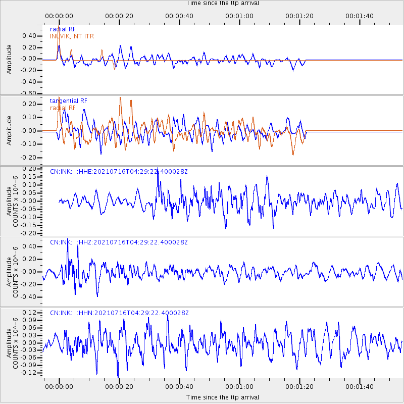
INK INUVIK, NT - Earthquake Result Viewer
*The percent match for this event was below the threshold and hence no stack was calculated.
| Earthquake location: |
Southeast Of Honshu, Japan |
| Earthquake latitude/longitude: |
33.3/139.5 |
| Earthquake time(UTC): |
2021/07/16 (197) 04:19:58 GMT |
| Earthquake Depth: |
11 km |
| Earthquake Magnitude: |
5.5 Mww |
| Earthquake Catalog/Contributor: |
NEIC PDE/us |
|
| Network: |
CN Canadian National Seismograph Network |
| Station: |
INK INUVIK, NT |
| Lat/Lon: |
68.31 N/133.53 W |
| Elevation: |
44 m |
|
| Distance: |
58.4 deg |
| Az: |
25.839 deg |
| Baz: |
280.977 deg |
| Ray Param: |
$rayparam |
*The percent match for this event was below the threshold and hence was not used in the summary stack. |
|
| Radial Match: |
68.6433 % |
| Radial Bump: |
400 |
| Transverse Match: |
59.075844 % |
| Transverse Bump: |
400 |
| SOD ConfigId: |
25131211 |
| Insert Time: |
2021-07-30 04:29:48.796 +0000 |
| GWidth: |
2.5 |
| Max Bumps: |
400 |
| Tol: |
0.001 |
|
Signal To Noise
| Channel | StoN | STA | LTA |
| CN:INK: :HHZ:20210716T04:29:22.400028Z | 2.9182668 | 1.5450992E-7 | 5.2945783E-8 |
| CN:INK: :HHN:20210716T04:29:22.400028Z | 1.3221262 | 3.1085904E-8 | 2.3512055E-8 |
| CN:INK: :HHE:20210716T04:29:22.400028Z | 2.3480992 | 7.004381E-8 | 2.983E-8 |
| Arrivals |
| Ps | |
| PpPs | |
| PsPs/PpSs | |


